
Boats row here no more
Once the lifelines of Dhaka, the city's canals are now mere shadows of their former selves—clogged with pollution, suffocated by encroachment, and neglected due to flawed urban planning. In this seven-part series, The Daily Star explores the current condition of the capital's canals, botched restoration attempts, and how the sorry state of these waterways is exacerbating the city's waterlogging woes. Together, these stories reveal what it will take to bring Dhaka's dying canals back to life. Here is the fifth part of the series:
Once upon a time, boats would glide through the waters of Karwan Bazar. Laden with goods -- sacks of rice, fresh vegetables, timber, and pottery -- these boats would anchor at the dock near what is now the Film Development Corporation.
 For all latest news, follow The Daily Star's Google News channel.
 Traders shouted prices, buyers haggled, and boatmen rested their oars to share stories of their journey over cups of tea.
This continued until the early 1980s, when waterways were a vital means of communication in Dhaka.
But those days are now a distant memory, replaced by traffic jams on roads and the towering presence of endless concrete.
Mindless encroachments, sprawling road networks, and flood control measures sealed the fate of Dhaka's boat culture, severing its connection with the rivers and canals that once sustained it.

According to locals, the turning point began with the construction of the Tongi Diversion Road and the Rampura stormwater pump station.
These projects disrupted the natural water flow and blocked boat communication in many areas.
A 36-kilometre embankment from Tongi to Killarmore in Lalbagh and a 3.8-kilometre floodwall plus road from Killarmore to Postogola further compounded the problem.
The embankments may have safeguarded the city against flooding, but they also cordoned off 136 sq km of Dhaka, cutting off crucial waterway routes.
The Rampura stormwater pumping station, constructed in 1993, became a definitive barrier.
While boats could still row between Rampura Bridge and the eastern parts of the city partially, the western and central part have lost connectivity totally. Though the water bus service is still active in the Hatirjheel part, it is confined to this waterbody due to a lack of connectivity.
"In the 1970s, the Begunbari canal [now Hatirjheel] was alive with activity," recalled Azizur Rashid Babu, a resident of Moghbazar.
"Boats would come from the Buriganga and Balu rivers, carrying everything from fresh produce to construction materials. But after the Rampura regulator pump and the Tongi Diversion Road were built, it all came to a halt," he added.
THE LOST CANALS
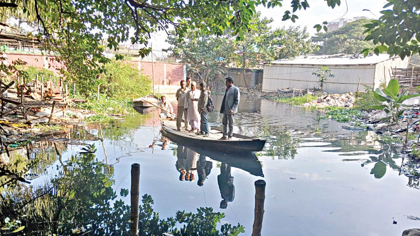
Dhaka's waterways, once its veins, have become ghosts of their former selves.
Canals like Hazaribagh, Rayerbazar, Ramchandrapur, Katasur, Gabtoli, Kallyanpur, Dhanmondi, Razabazar, Kathalbagan, Paribagh and Begunbari have lost their navigability.
Many are now choked by encroachments and garbage or buried under concrete roads and box culverts.
The construction of roads by encroaching upon the waterways further deepened the problem.
By the 1990s, the docks of Karwan Bazar had transformed into relics of a bygone era.
Dhaka has lost 120km of canals, covering 307 hectares, due to encroachment, unplanned urbanisation, and negligence, according to a 2022 study by the River and Delta Research Centre (RDRC).
The study, led by Mohammad Azaz of RDRC, compared the 1880-1940 Cadastral Survey with satellite images from 2022.
The decline of Dhaka's waterways represents more than a shift in transportation; it marks the loss of a culture intrinsically tied to the city's identity, experts told this correspondent.
Rowing boats in Dhaka was not merely a mode of transport, but a livelihood for many and a connection to the city's ecological balance, they added.
Today, Dhaka struggles with its swelling population and relentless urbanisation.
Traffic congestion has become a daily nightmare, and the city's clogged drains and waterlogging during monsoons are reminders of the price paid for sidelining its waterways.
IMPACT OF INFRASTRUCTURE ON CANALS
The construction of box culverts and roads worsened the situation, reducing many canals to mere names, while others vanished entirely, said experts.
Former BWDB Chief Engineer (central zone) Abul Kalam Azad said the embankment, built between 1992 and 2003, included three stormwater pumping stations at Goran Chatbari, Kallyanpur, and Dholaikhal, alongside 54 sluice gates.
Dr Ainun Nishat, a water resources and climate change specialist, said Dhaka's original development centred on the eastern bank of the Buriganga.
The city expanded to the east and north as those areas were highlands.
Adabor and Kallyanpur, now densely populated residential areas, were once regularly submerged until 1987.
Nishat recalled large boats navigating areas like Russell Square and Rampura in the 1970s and 1980s.
"A canal once flowed from the bedding shops at Nilkhet, with one lane of the road in front of Eden Mohila College serving as a waterway," he said.
MISSED OPPORTUNITIES IN FLOOD MANAGEMENT
The embankment construction followed the devastating 1988 flood.
While the government approved 11 guiding principles of flood management in 1989, including environmental considerations and open canal mouths, these recommendations were largely ignored.
Smaller sluice gates were built to reduce costs, limiting water flow and navigation.
Nishat, one of the key architects of the management principles, said, "We urged the government to focus on road networks rather than embankments, which could have preserved marshlands in the western part of the city."
He emphasised that larger sluice gates and boat-crossing facilities could have maintained navigability, allowing people to access rivers via canals.
ALARMING RAINFALL PATTERNS
The current state of Dhaka's waterbodies is particularly concerning considering the shifting rainfall patterns.
Nishat highlighted recent instances of extreme rainfall -- 350mm in a day in Khagrachhari and nearby areas, and 200-250mm in Mymensingh-Netrakona.
"Dhaka can face 300mm of rainfall at any time. Even with 50mm of rain, half the city floods. If rainfall reaches 100mm, 60-70 percent of the city gets submerged. A 300mm event would be catastrophic," Nishat warned.
The experts called for urgent government action to recover canals based on Cadastral Survey (CS) and Revisional Survey (RS) maps.
Reviving circular navigation routes, even through land acquisition, is essential, they said.
"The courage to reclaim these canals is lacking in political governments," Nishat said.
"This interim government has a unique opportunity to act. It may be the last chance to recover these waterways before it's too late."
He said Dhaka's natural drainage system once relied on the Balu River in the east, the Shitalakhya in the southeast, the Turag and Bangshi in the west, and the Buriganga and Dhaleswari in the southwest.
These rivers were interconnected by canals, forming a circular waterway around the city.
"In developed countries, navigable canals are preserved, with water buses providing smooth transport. Dhaka must follow suit to ensure its survival," Nishat said.


Comments