
Delimitation of maritime boundary brooks no delay
 For all latest news, follow The Daily Star's Google News channel.
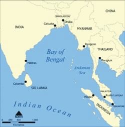
 A report under the headline “Seismic survey appears crucial to retain maritime boundary” published by some newspapers on July 22, 2008 said that the seismic survey of Bangladesh's territorial sea line appeared crucial as a UN set deadline for lodging maritime claims will expire in next three years exposing the country to the risk of losing a vast territory in the Bay of Bengal.
The report quoting experts and some relevant people underscored the need for establishing Bangladesh's claim in the sea for the huge resources -- gas, oil and other aquatic resources. It is also important from national security point of view, it said quoting LT. General (retd) Mahabubur Rahman, former Chairman of the Parliamentary Standing Committee on Defence.
It may be recalled that Bangladesh signed the UN Convention on the Law of the Sea called UNCLS in 2001 under which it is under the obligation to lodge its claim on the maritime boundary by 2011.
According to General (retd) Mahabub. “Unfortunately we could not make any major headway in lodging our claims through seismic and other studies despite the fact that we could lose an area in the sea which is larger than the mainland Bangladesh.” Sounding a note of caution he said that neighbouring India and Myanmar have already made progress in crisscrossing Bangladesh's territorial shoreline.
At least 13 organizations were asked to complete hydrographic survey of the entire coastline of Bangladesh and geographical survey of CS in 2004 but excepting our naval force none could finish their job. Meanwhile, both India and Myanmar have floated tender for seismic survey, the report said emphasizing the need for Bangladesh to undertake seismic survey of the country's territorial sea line.
The Navy completed the task of Bathymetric Mapping of northern part of the Bay of Bengal and mapping of the geology and geomorphology of the coastal areas and submitted the same to UNCLS Desk of the Ministry of Foreign Affairs. Other organizations attributed their lapses to shortage of skilled manpower, lack of fund or logistic support.
Nothing was heard about the tiny island in the estuary of the Bay of Bengal known as South Talpatty in Bangladesh and New Moore in India during 1996-2001. It was raised with India when Lt Gen (retd) H.M.Ershad was in power and again during BNP rule in 1991-96. The Parliamentary Standing Committee on Defence with former chairman of the Committee Mahabubur Rahman recommended for strengthening the Navy for intensifying the security of maritime boundary and also tapping unexplored natural resources of the sea .
On the ownership of the island South Talpatty people have a right to know the progress of talks between Bangladesh and India on the question of establishment of Bangladesh's claim on the island, which hit the headlines in the print media of our country during early 1980's.
The issue was heard on February 10, 2003 when former Foreign Minister M.Morshed Khan told newsmen that the government would discuss all bilateral issues including South Talpatty with India. He identified seven unresolved issues with India in the Jatiya Sangsad including the South Talpatty.
According to Khan the demands for resolving these issues were not only raised from Bangladesh side, but in India itself some important political leaders as well as civil societies also want solution to those issues. Quoting the Indian civil societies he said as Bangladesh was one of the biggest Indian markets so New Delhi in its own interest should sit with Dhaka with an open mind and find solutions to those issues.
In this context, it needs to be recalled that during the then prime minister's official visit to India the Talpatty issue was raised in May 1992 in the joint communique issued at the end of the visit.
The ownership of the newly emerged islands in the estuary of the border river Hariabhanga between Bangladesh and India, has been claimed by both countries as forming an integral part of their respective countries.
Talpatty has a surface area at low tide of about 2.2 square km as per assessment of 1978. Excepting some fishermen from Bangladesh mainland using it seasonally for drying their fish nets it was uninhabited. The island is about 5.5 km from the Indian coast and 7.5 km from Bangladesh coast.
It was described by Bangladesh officials as a violation of an agreement reached between former Indian PM Morarji Desai and President Ziaur Rahman of Bangladesh for a joint survey, to determine the location and ownership of the island.
The commitment for a peaceful and early settlement of the issue was reaffirmed by the foreign ministers of Bangladesh and India on August 18, 1980.
On May 28, 1981 the Jatiya Sangsad adopted a resolution after debate on the Talpatty issue protesting against the illegal Indian action on May 9, 1981 in landing armed personnel, erecting structures, hoisting the Indian flag on this island and sending armed naval ships in the internal waters of Bangladesh.
On May 23, 1981 the Indian media reported that Bangladesh's claims to the New Moore island had been disproved by the first results of the survey conducted by INS Sandhayak. This had been done with the help of “sophisticated equipment” which had provided a “mass data on the location and features of the island and the waters surrounding it.”
Ministry of Foreign Affairs of Bangladesh in a press statement issued on May 25, 1981 expressed its surprise over “ the untenable and unilateral Indian claim.”
Eric Gonsalves, the then Indian External Affairs Secretary informed Bangladesh High Commissioner in the same month that India had removed its personnel from South Talpatty/New Moore Island and also its ships. The then Indian High Commissioner to Bangladesh had conveyed this in Dhaka.
Bangladesh, while welcoming the gesture informed the Indians that since nothing was conveyed in writing it would be better if an announcement was made publicly to defuse tensions on the issue between the two close neighbours. A joint statement was issued following negotiations between the two sides expecting that in a spirit of good neighbourly relations the issue of South Talpatty would be resolved.
Meanwhile, according to an official of the Ministry of Foreign Affairs of Bangladesh neither India, nor Bangladesh or Myanmar can harness hydro carbon resources of the Bay of Bengal (since claims are overlapping) without resolving the issue of delimitation of maritime boundary. Bangladesh should take the issue to the international forum to establish its rightful claims if it fails to find negotiated settlement with the neighbours, he said requesting anonymity.


Comments