
"Waterfronts" to remain hot
Bangladesh lies on the confluence of three major rivers of Asia, namely the Ganga, Brahmaputra and Meghna. The watershed basins of these rivers cover the center, north and northeastern part of South Asia, and the Great Himalayan Range. The catchments area of the three river Basins is about 1,761,300 sq. km in total, of which 120,400 sq. km (7% only) lies in Bangladesh. As those rivers fall in the Bay of Bengal through Bangladesh, it becomes a country of rivers by their distributaries. More than 1000 rivers can be traced during monsoon and floods, though only about 200 rivers now flow round the year. Bangladesh has 57 common rivers originating in India, Nepal, China, Bhutan and Myanmar, comprising of those three main rivers and their tributaries. Those common rivers are being prevented of their historical flows by upland countries through dams and barrages, causing severe environmental and socioeconomic impacts on the people living in Bangladesh. The inland rivers are subject to pollution, grabbing and filling, which are leading to their death and creating severe environmental degradation. Thus, Bangladesh has two categories of waterfronts: one on the borders of those common rivers, the other on the inland rivers; where war is being waged by the people of this country, led by the environmentalists, against those aggressions.
The Ganga originates from the southern slopes of Himalayas, and has a traveling length of 2550 km. Its tributaries originate from both the Himalayas and the central highlands of India. The Gangetic delta formed by the distributaries of this river is the largest in the world, covering about 105,000 sq. km. 20% of it is in India and 80% in Bangladesh. The Brahmaputra originates from the northern slopes of Himalayas, and has a traveling length of about 2900 km. Its tributaries originate from the Kailash Range, Tibetan Plateau, the Himalayan Range, the Lushai Hills and the Garo & Jaintia Hills. The Meghna originates from the Lushai Hills. Its tributaries originate from the Lushai Hills, and the Garo & Jaintia Hills. The distributaries of those two rivers also contribute to the formation of Gangetic Delta. From historical times, all those three rivers have changed their main courses several times within this delta, through their distributaries.
 For all latest news, follow The Daily Star's Google News channel.
 The Bengal basin stretches from the Chotonagpur Highlands of Central India to the Lushai Hills of the India Myanmar border, and from the Himalayas to the Bay of Bengal. This basin covers the whole of Bangladesh, Bhutan, West Bengal, and the seven northeastern states of India. Bangladesh being at the center of this is mostly the flood plain of two major rivers, the Ganga and the Brahmaputra. A part of Bangladesh to the north, east, and southeast is hilly, but also has plains of the Meghna and some other independent rivers. The Bengal plain is divided mainly into two countries, India and Bangladesh. This division did not follow any natural barrier but was made politically. Thus, we can find rivers originating in Bhutan travelling through India then passing through Bangladesh (the Dharla River). The Mahananda and Dahuk rivers enter Bangladesh but leaves to fall in the Ganga in India. Some rivers originate in Bangladesh, travel through India, then again enter Bangladesh (Atrai, Punarbhaba, Betna). Thus, the water resources generated in the Bengal Plain become very much inter-dependant between India and Bangladesh.
Hundreds of rivers, big and small, crisscross the land of Bengal Plain from north to south towards the Bay of Bengal. But morphologically, the Bengal basin can be divided into 4 major river systems, 1) the system of the Ganga River, 2) the Brahmaputra River, 3) the Meghna River, and 4) of the southeastern hilly rivers. These systems have major, medium, and minor rivers as tributaries and distributaries. The source of surface water in Bangladesh is the rainfall fallen over this country, and the stream flow coming in from outside this country. With an average annual rainfall of about 2300mm, it generates about 276 Million-Acre Feet (MAF) of water locally. Water coming from outside by stream flow is estimated at about 818 MAF annually. Thus, the total water resource generated in this country is about 1094 MAF or 1350 Billion Cubic Meter (BCM) annually. However, most of this huge resource runs down to the Bay of Bengal, to form brackish & sweet water mixed ecosystems in the estuaries. The water brings down about 1400 million tons of silt annually through Bangladesh, to deposit over the flood plains and in the Bay of Bengal.
The surface water resource of this country is very much essential for its human and animal living, aquatic flora and fauna, navigation, agriculture, etc. It is also necessary for keeping alive the distributaries in the delta, and maintaining the brackish water ecosystem along the sea, on an annual cycle. The groundwater system of Bangladesh named the Dupi Tila aquifer gets annual recharge from the surface water. Thus, the surface water is essential for keeping the environmental balance of the total region, particularly in the estuaries to the south, and at the mouth of the rivers. The breeding of Hilsa in the estuaries and breeding of shrimps along the continental shelf matters significantly on the sweet water flow coming from the uplands. Along the coastlines the ecosystem of Bangladesh varies in character from west to east depending on the availability of sweet water coming from the upland sources. Some fishes are indigenous to Satkhira rivers are unavailable to other parts of the coastline because water quality changes.
Prevention of historical flows in common rivers by India has come down heavily on the life of people, agriculture and economy of Bangladesh. The crops in Bangladesh are grown in three distinct cropping seasons. These seasons are according to the Bangla solar calendar, equally divided in four months each. The crops' life periods are either of one season, or two seasons, or full year long. Rice is grown twice a year during Kharip I and Kharip II seasons. Oil seeds and pulses are grown in the Rabi season. Sugarcane is grown on a full year long period. In the last couple of decades rice is also being grown in Rabi season. But all these crops need water in the form of soil moisture or irrigation. For both these support surface water in the rivers and groundwater below the soil surface is essential. Some crops having low water-need can be fed by good soil moisture with groundwater support only. Rice needs large amount of water so needs irrigation in absence of regular rainfall. If historical flows in the rivers were maintained crop intensity could be planned depending on the surface water available. But historical flows of our rivers are being checked by the upland countries.
India started intervening to the Ganga River flow since British times by building dams and barrages over it and its major tributaries named Jamuna, Ramganga, Sarda, Ghagar, Gandak, Kosi, Chambal, Betwa, Son, and others to produce hydroelectricity and for irrigation. The Farakka Barrage was the final onslaught over it resulting in withdrawal of the residual flow coming towards Bangladesh. Every river has a character of flood flow and base flow. The flood flow is the highest quantity of water discharged when excessive rainfall occur in the basin. The base flow is the discharge coming from springs and drainage water from the lowlands. The base flow gradually reduces after the monsoon and reaches to the lowest in winter. Some rivers receive snowmelt water of the Himalayas at the start of spring season when their flow rises. But rivers coming from arid regions have their base flow go lower in spring and summer, until the monsoon returns. The Ganga used to get snowmelt water in the past but that water was diverted to the irrigation areas of Uttar Pradesh and Bihar in India. Whatever residual flow of the base flow of Ganga River arrived towards Bangladesh was diverted to the Hooghly River through a link canal from the Farakka Barrage.
India has extensive plan to build dams over the Brahmaputra River and its tributaries and has executed or executing some of its projects. It has similar programs ongoing over the tributaries of the Meghna River. But in addition, it has a large programme to interlink the rivers of Brahmaputra Basin with the rivers of Ganga Basin in the name of India's River Linking (IRL) Project. This IRL Project would divert a large amount of base flows of the rivers in Brahmaputra Basin towards the arid regions of Rajasthan, Gujarat, and southern Indian states. This will have extremely disastrous effects on Bangladesh. India has already built dozens of dams in the Teesta Basin and diverting its residual flow towards Ganga basin putting obstruction by the Gazaldoba Barrage. Teesta is a tributary of the Brahmaputra River, so they have already executed a major part of their IRL Project. Thus India is taking away our historical rights on the rivers, on which our human life, animal life, plants, agriculture, economy etc. depends. But whenever any diplomatic effort is made from our government India says, 'we will not do anything that will harm Bangladesh'.
This transfer of water from Brahmaputra basin to Ganga basin is totally unacceptable. It violates the International Convention on Non-navigational uses of Watercourses of 1997 in force since 17 August 2014. Water of a river can be used on equitable basis where the minimum historical flow has to be maintained for the life of the river, and not to cause harm to other state. The watercourse convention Article 7.1 puts obligation that 'Watercourse States shall, in utilizing an international watercourse in their territories, take all appropriate measures to prevent the causing of significant harm to other watercourse States.' Article 7.2 says, 'Where significant harm nevertheless is caused to another watercourse State, the States whose use causes such harm shall, in the absence of agreement to such use, take all appropriate measures, having due regard for the provisions of articles 5 and 6, in consultation with the affected State, to eliminate or mitigate such harm and, where appropriate, to discuss the question of compensation.' On 20 September 2014, the India reiterated its earlier commitment in article 25 of the `Joint Statement on the Third Meeting of the India-Bangladesh Joint Consultative Commission', that it would not take any unilateral decision on the Himalayan component of the proposed River Interlinking project which may adversely affect Bangladesh.
Now China has completed its first hydropower dam on the Brahmaputra Basin at Zangmu in Tibet, to generate 510MW hydroelectricity. India seems to have withdrawn from its position to oppose Chinese moves being satisfied by their explanation that it is a 'Run off the River' dam, not to harm the river flow to downstream. The reality is, India also says, the dams built on Teesta River are 'Run off the River' dams. This is mere bluff, as 'Run off the River' dams cannot produce hydroelectricity round the year unless the base flow is restricted and stored in the dam reservoir. The dams in Sikkim are doing this; for this Teesta River's historical flow diminished. The situation is Bangladesh government lacks good homework to show the adverse effects in Bangladesh because of water withdrawals in the upstream. For this reason, people and activists in Bangladesh had to come forward and take up their war to the waterfronts for their historical rights.
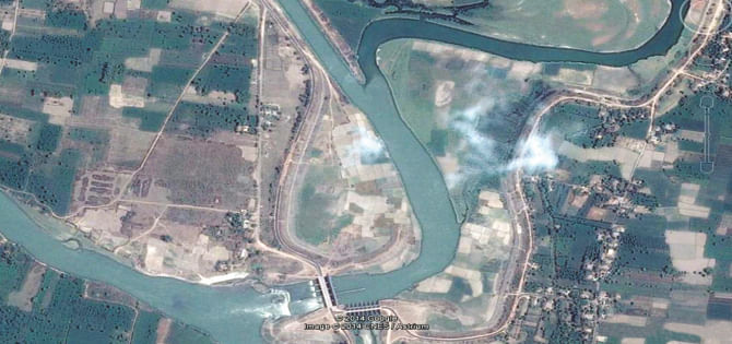
In April 2014 we saw several political parties waged long marches towards the Teesta River in protest of the Indian actions. A Google Image dated 16 April 2014 shows the Teesta water being diverted and released in the Dahuk River of West Bengal which has outfall in the Fulhar River upstream of Farakka Barrage. On that date Teesta River was left dry inside Bangladesh creating severe damage to the crops in Teesta Project areas. War is also being waged by the people to free our inland rivers from pollution, grabbing and filling. These are causing unnatural death of many rivers, and severe degradation of human and animal life depending on them. In 2015, this war to be definitely continued as we cannot let this country fall into a dark future.
The writer is Chairman, Institute of Water & Environment. Email: [email protected]


Comments