
Satellite remote sensing : Efficient tool for fisheries development
 For all latest news, follow The Daily Star's Google News channel.
 Remote Sensing is the process of sensing and measuring objects from a distance without physical contact with them. Satellite remote sensing observation systems brought with it the capability to synoptically survey vast areas in unprecedented detail. It appears feasible to use satellite sensors to measure selected parameters and then to use these measurements to predict the distribution and abundance of fisheries resources. Remote sensing technique can provide considerable information at a minimal cost and time for this type of study. This technique can be used reliably and effectively to map location, size, quality of wetlands and some aspects of habitat. Bangladesh Space Research and Remote Sensing (SPARRSO) has developed remote sensing techniques effectively and efficiently to locate, identify and quantify our inland, coastal and marine fisheries resources habitat. Some of the works accomplished by SPARRSO are as the following:
Water bodies survey : For proper planning, management and development of fisheries, it is necessary to know the extent, condition and location of the different types of water bodies of the country. In view of this SPARRSO undertook a survey work of water bodies using remote sensing technique in 1980. Maps at the scale of 1:50,000 of small water bodies (less than 25ha) in 40 selected thanas were produced. Large maps were produced showing the location of water bodies, communication network, and physical infrastructures using aerial photographs and Landsat satellite. Fisheries Directorate has used these maps for their planning, development and management of inland and coastal fisheries resources.
Updating inventory of waters using remotely sensed data and GIS: This is the partly updating of the previous study on water bodies survey of Bangladesh using remote sensing technique. This study has been made on water bodies of three administrative districts of Bangladesh namely Jessore, Sylhet and Natore using infrared aerial photography, SPOT satellite images in 1991.Eleven maps of 1:50,000 scale were prepared for the three districts showing different types of water bodies and infrastructures which are relevant to fisheries and water resource management in these areas. Chlorophyll content and different types of water bodies were classified with this image using GIS/ARC-INFO. Optimal fish ponds, potential areas of fish culture and fish processing industry were also identified.
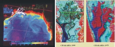
Mangrove ecosystem study of Chakaria Sunderbans: Mangrove ecosystem of Chakaria Sunderbans was studied to identify shrimp ponds and monitor temporal changes and their impact on the ecosystem using aerial photography and Landsat satellite data in 1983. These maps were used to identify shrimp ponds and to assess the spatial coverage and temporal change in mangrove ecosystems. A suggestion was put forward for planting mangroves on the periphery of embankments of shrimp farms to balance the ecosystem. Such suggestion has been implemented at Ecuador of South America and in South East Asia and they got good result. After 1999, it was realized that, this suggestion should have been followed earlier in Bangladesh. If it was followed before 1991 then severe cyclone of 1991 would not have destroyed so much of our coastal area and shrimp farms.
Estimation of chlorophyll content of Bay of Bengal: Presence of phytoplankton can be considered as an index of biological productivity and it can be related to fish production. An attempt was therefore made to find the chlorophyll concentration in Bay of Bengal using Nimbus-7(CZCS) satellite data in 1991. The analysis showed that, chlorophyll content of the Bay varied between 0.1 and 10.0 mg/m3. Chlorophyll is found to be higher near the coast, because of availability of maximum nutrients which are drained through the rivers. Analysis of chlorophyll concentration is helpful in surveying the potentiality of fisheries resources of the sea. These data are also useful for estimation of global carbon cycle.
Coastal zone development and fishery environment analysis: The SPARRSO and Indian Space Research Organization (ISRO) have completed the study and coastal maps have been generated for the two study sites --Khulna-Satkhira and Cox's Bazar. The whole zone development and fishery environment analysis was done using remote sensing techniques in Bangladesh under a UN/ESCAP, TCDC programme in 1997. In this study different satellite data, thematic maps, fieldmeasured data and other relevant published data and information etc were used. Detailed and updated landuse work was performed in six major parts and the model for suitable site selection of shrimp farm (4S Model) was developed. In some of the ESCAP countries, respective governments are using this type of model for allocating shrimp farms in their respective country. Our Fisheries Department should use this model.
Impacts of shrimp farm on rice and other agricultural land in the south- western coastal region : The aim of this study was to identify and monitor the agricultural land encroached upon by shrimp farming activities, preparation of map showing the encroached agricultural areas of rice and other agricultural crop production. The study area was Satkhira district. Landsat TM satellite data of different date and topographic maps were used for this study. Upazila wise maps were prepared and area statistics were generated on shrimp farm, crop land, and settlement areas in 2003.
Coastal and marine biodiversity: Status of coastal and marine biodiversity of Bangladesh was studied as fauna a total 453 species of birds, 42 species of mammals, 35 reptiles and 8 amphibian species for the whole coastal zone. A total of 301 species of mollusks and over 50 species of commercially important crustaceans have been recorded so far. Among the endangered species are 5 mammals,25 birds, 14 reptiles, 1 crocodile, 8 turtles,1 snake, 2 frogs, and 4 lizards, The marine waters of Bangladesh are also remarkable for being a habitat of 475 species of fishes and at least 36 species of marine shrimps. About 336 species of marine mollusks including coastal mollusks covering 151 genera, 3 lobsters and 7 species of turtles and tortoises, 168 species of seaweeds, 3 sponges,16 crabs,10 frogs, 3 crocodiles, 24 snakes, 3 otters,1 porcupine, 9 dolphins and 3 species of whale were found in Bangladesh territory of Bay of Bengal. Among the marine migratory species of animals 4 fishes, 5 reptiles, 6 birds and 3 mammals are threatened.
Monitoring fluctuations of water area in Sylhet-Mymensingh basin: The study describes monitoring seasonal fluctuation of water area in the Sylhet- Mymensingh basin using microwave remote sensing and GIS techniques. RADARSAT, Landsat satellite images, topographic and thematic maps were used as reference map for the study. Seasonal fluctuations of water areas for each district were calculated separately.
Conclusion: Remote sensing techniques can be utilised directly, indirectly or as general aid in the detection and assessment of fishery resources. Knowledge of the oceanographic conditions that affect the harvesting strategies and fishing operations is also developed in the neighbouring countries which can be utilized through regional cooperation (BIMSTEC). SPARRSO with its limited facilities has done some works on remote sensing applications in inland, coastal and marine fisheries resources. Some of them are discussed in this article. If we can utilize this study through fisheries department it will be easier for management and development our fisheries resources. This subject is rapidly developing throughout the world. If we do not proceed we will just lag behind. Especially our marine fisheries sector will lag far behind. So, some realistic projects using satellite remote sensing should be undertaken by Fisheries Department/fish farmers with SPARRSO and allied organisations without wasting time.


Comments