
A sustainable urban planning approach
 For all latest news, follow The Daily Star's Google News channel.
 Across the modern world, landscape ecology is beginning to provide a scientific basis for landscape and natural resource planning and management. Landscape ecology is the study of the interactions between the temporal and spatial aspects of various components of landscape; these components include Abiotic (water, nutrients, energy flow etc), Biotic (flora and fauna) as well as manmade Cultural (urban infrastructures, recreational facilities etc) components therefore landscape ecology addresses the ecological processes affected by the spatial structure of a large area intervened by human activities or natural system. Since there is a wide scope of anthropogenic intervention, the landscape ecology is subjected to planning i.e. sustainable planning.
The difference between the traditional ecological studies and landscape ecology, from this viewpoint, is the consideration of human activities, which are kept isolated from natural system in the typical ecological studies. The main focus of landscape ecology is on the structure, function and change of landscape. Structure relates to the composition (number, type and extent of landscape elements. The major landscape elements are Patch e.g. homogenous nonlinear area like forest area or urban built-up area, Corridor e.g. linear element like river or expressway and Matrix e.g. the over all landscape combined with patch and corridor) and Configuration (position, orientation and arrangements of landscape elements).
The functions of landscape usually refer to the of flora, fauna, energy, mineral nutrients and water between landscape elements (Forman and Gordon 1986; Forman 1995). Thus, the functions are mainly 'services' in the form of production (e.g. food, wood, recreation etc), protection (e.g. rainfall infiltration, oxygen production, CO2 absorption etc) and regulation (maintaining the stability of over all landscape) that provided by landscapes. Any natural or manmade change in the structures of landscape i.e. subdivision and fragmentation of natural habitat, construction of dams and embankments on the water way, filling up low land, construction of road dividing agricultural or forest land and so on would change the functions of it. Both nature and cultural systems mutually interact to generate landscape pattern to influence the functions within it and affect the change.
Landscape planning attempts to influence specific changes in the pattern of landscapes with particular consequences for ecosystem structure and function. In a book named 'Measuring Landscapes' Leitao, A.B. et. al. (2006) there is used a landscape metrics capable of determining the composition and configuration of landscape. The ten set of landscape metrics described in this book are able to measure the geometric properties of landscape elements, and their relative positions and distributions (composition and configuration) are useful for landscape planning because landscape structure influences ecological functions and processes. The ten metrics are: i. Patch Richness (PR), ii. Class Area Proportion (CAP), iii. Patch Number (PN)/ Patch Density (PD), iv. Patch Size (AREA_MN and AREA_AM), v. Patch Shape (SHAPE), vi. Edge Contrast (ECON), vii. Patch Compaction (GYRATE), viii. Euclidean Nearest Neighbour Distance (ENN), ix. Proximity Index (PROX), x. Contagion (CONTAG).
All these metrics can be calculated from vector based data or cell based image using GIS tools or a recommended software named FRAGSTAT. Landscape metrics can be used to characterize a wide variety of spatial patterns as they measure composition and spatial configuration of landscape elements as well as the metrics can be used to characterize the individual landscape elements, collection of landscape elements of same types and entire collections of diverse landscape elements. The spatial patterns can affect the wide variety of ecological processes, which in turn can affect spatial pattern, and this interplay is the prime focus of Landscape Ecology. Because of the relationship between spatial pattern and processes, landscape metrics can inform planners about landscape functions.
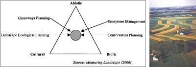
Planning or spatial planning goal is to organize function and space in a way that can achieve best mutual relationship and this can be best realized by ABC triangle and the current planning activities are converging towards the core of the triangle, i.e. the integrated approach of spatial planning. For example: park connecting planning in Singapore has taken into consideration the activities like green enhancement, recreation and urban development, in many countries water resource planning is evolving towards integrated watershed approach considering ABC resources altogether.
Although often originating with a recreational focus, greenway planning also combines natural and cultural goals because it recognizes the connectivity as key to providing multi-functional corridors for hydrological management, species movement, recreation and cultural landscape preservation. The importance of maintaining connectivity is a subject of major research area and for its ubiquity is not discussed here. But to offset the loss of green due to urban development the environmental planners are cautiously suggesting promoting green culture in buildings especially in densely developed cities like Singapore, New York. Greening in the form of vertical gardening, roof or terrace gardening is able to perform the following functions: Reduce urban heat; Attract bio-diversity; Increase aesthetic quality; Conserve energy.
In face of rapid urbanization and consequent deterioration of environment and biodiversity, Sustainable urban planning is a must for numerous reasons and landscape ecological planning therefore would be the best approach to accomplish the task.


Comments