
Law of maritime delimitation
 For all latest news, follow The Daily Star's Google News channel.
 Nature is not uniform and human beings cannot refashion nature. The boundaries of coastal states are accidental or historical or arose out of colonial history. States have to live with neighbours that cannot be changed.
The jurisdiction on the sea originates from the land domain that borders sea. That is why land-locked states do not claim jurisdiction on the sea.
Bangladesh is fortunate to have the Bay of Bengal in the south. Access to the Bay of Bengal is a significant natural asset of the country because through the Bay of Bengal an easy access is available to the vast Indian Ocean and the major sea-lanes of international trade.
As land resources deplete, states are falling back on sea resources (mineral and living) which are, according to scientists, richer in content than those found in the land.
Maritime Delimitation Law
Coastal states have to delimit their sea boundaries with neighbouring states. Maritime delimitation law is complex and is evolving.
The law can be regarded largely composed of the relevant provisions of the 1982 UN Convention on the Law of the Sea (UNCLOS), jurisprudence as gleaned from judgments of International Court of Justice (ICJ) and other international tribunals.
The UNCLOS accords top priority to conclusion of bilateral agreement on maritime delimitation.
The UNCLOS provides that states may agree on the basis of international law, as referred to Article 38 of the Statute of International Court of Justice in order to achieve an equitable solution.
Article 38 of the ICJ Statute consists of two paragraphs and they are as follows:
1. (a) International conventions, whether general or particular, establishing rules expressly recognized by the contesting states
(b) International custom, as evidence of a general practice accepted as law
(c) The general principles of law recognized by civilized nations
(d) Subject to provisions of Article 59, judicial decisions and the teaching of the most highly publicists of the various nations, as subsidiary means for the determination of rules of law.
2. This provision shall not prejudice the power of the court to decide a case ex aequo et bono, if the parties agree thereto.
It is argued that paragraph 2 of the above Article gives the flexibility of a court to decide a case on laws and principles outside the normative framework, if the parties agree.
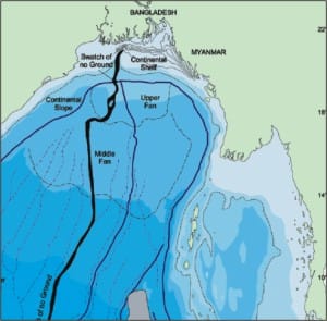
The Continental Shelf of the Bay of Bengal
The continental shelf of the Bay of Bengal constitutes a single continuous shelf. The rivers of the mighty Ganges, Brahmaputra and Meghna flow through Bangladesh and meet at the sea.
Much of the continental shelf can be argued to be the deposit of silt through the rivers through Bangladesh. The continental shelf is not steep but runs in a steady and gradual slope from the coast of Bangladesh. In other words, it can be argued had there been no large rivers flowing through Bangladesh carrying silt (2.4 tons of silt annually), the continental shelf would not have existed, as Sri Lanka has almost nil continental shelf.
The continental shelf is arguably a natural prolongation of the landmass of Bangladesh in the southward direction. Some experts say that it runs more than 350 miles from Bangladesh coast.
Law of delimitation of continental shelf:
The 1969 Judgment of the ICJ on the North Sea Continental Shelf Case, the 1977 Anglo-French Continental Shelf Case, the 1982 Tunisia-Libya Continental Shelf Case, the 1984 Gulf of Maine Case and the 1985 Libya-Malta case have arguably led to certain ambiguity in the law of delimitation. This is not uncommon because each situation is different from the other not only in geographical sense but also in other circumstances.
It is argued that each delimitation case has its unique factual matrix. The " principle" of equidistance is discounted as a principle and is only a technique for achieving equitable solution in delimiting maritime boundaries between opposite states and has not attained the same normative status as the principle of equity.
The interpretation of customary international law of maritime delimitation as embodied in the 1969 ICJ judgment and Articles 74 and 83 of the UNCLOS, provide strength to the above argument that equity has emerged as integral part of law in maritime delimitation. States may take recourse to various factors to achieve an equitable solution.
There are generally two techniques or methods of delimitation:
(a) equidistant method/special circumstances
(b) natural prolongation of territory
It is argued that equidistant method that applies to opposite states (India-Sri Lanka) achieves equitable result while between adjacent states, it distorts outcome unless special circumstances/other factors are fully taken into account.
The factors among others are:
* whether the coast is concave or convex
* presence of islands or islets
* presence of navigational channels
* geo-morphological condition of the coast
* state of natural resources
* needs of economic development
* size of the population in context of the size of the territory
* easy and open access to the high sea and International Sea bed Area
In the past international jurisprudence used to "lionize" only geographical factors to the virtual exclusion of other factors and it is now outdated because all relevant factors must be taken into account to achieve equitable solution.
The natural prolongation principle is rooted in the 1969 ICJ judgment. For example Bangladesh's continental shelf consists of its natural prolongation of its landmass from its southernmost tips into the Bay of Bengal.
The natural prolongation principle is further concretized by taking into account and giving due weight to all relevant factors in a given delimitation area
Interim period
Ordinarily, the delimitation of maritime boundary takes a long time and if there is an issue of overlapping maritime areas that remains disputed and unresolved, the experience and lessons of many states are one of cooperation to a provisional agreement of joint development and exploration.
For example, Japan-South Korea Agreement of 1974, Malaysia-Thailand Agreement of 1990 and Thailand-Vietnam Agreement of 1992 on Joint Development Zones are instances in point.
Both parties put aside their contested positions, meaning that status quo of the area is preserved or undisturbed. Both sides generally make concessions on a reciprocal basis concerning the most difficult question of the principles and rules to be applied as its basis for delimitation of territorial waters/exclusive economic zones/continental shelf. Such reciprocal concessions are made without prejudice to the official position of the respective parties on the question of maritime delimitation.
Conclusion
Given the days of energy shortfall and rising prices of oil and gas, exploration of maritime areas in the Bay of Bengal has become more urgent than it was in the past. It is commendable that under the initiative of the caretaker government, discussion with Bangladesh's neighbours on the issue of delimitation of maritime boundary has started and hopefully equitable solution is achieved for benefit of both parties.


Comments