Prediction and monitoring of disasters in Bangladesh

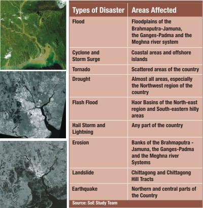
Satellite Image of Bangladesh (taken in October 2001, by Google Eearth ) showing the low elevation and the main rivers, top left, and standard beam mode RADARSAT-1 images (25m resolution) acquired on October, 21, 2001 and May 7, 2008 following Cyclone Nargis.
Microwave remote sensing technologies have been successfully used in different disaster management and risk assessment schemes in different countries of the world for quite some time now. Bangladesh, because of its unique geographical location, is prone to natural disasters such as flash floods, cyclones and storm surges, tornadoes, drought, hailstorm and lightning, erosion, landslide and earthquake. These disasters cost a huge loss in lives and property. Proper monitoring and accurate forecast can save many lives and huge amount of money. It is high time that microwave remote sensing technologies, which provide a much better alternative to existing technologies in use, are used more extensively than they are being done now.
The microwaves are part of the electromagnetic spectrum and their wavelengths range from 1 mm to 1m. The range of frequencies this covers is between 3000 to 30,000 MHz (3-30 GHz). The microwaves exhibit unique capabilities in remote sensing and they have a number of stand-alone applications. The fact that microwave observational facility works equally well in all weathers as well as in both day and night time helps in using microwave sensors for different land based, atmospheric and oceanography applications including disaster management. Remote sensing technologies, being used by different countries including the neighbouring country of India, provide a much better alternative compared to existing technologies in use.
Microwaves are specially suited for Remote Sensing because of several reasons: they can penetrate clouds, they are independent of the sun as a source and can hence be used in day as well as night and lastly, they can penetrate deeper into vegetation compared to optical waves. Furthermore, microwaves are capable of penetrating into the ground itself.
The potential of using satellite based microwave observations of soil moisture to improve flood predictability is a concept that is being explored in different parts of the world today. Remote sensing observations could add skill to predictions of flood peak timing and magnitude. The inundated land surface conditions displayed are a detectable precursor to subsequent downstream flooding. The use of remotely sensed passive microwave observations improves the forecasting skill for regional scale flooding. In Bangladesh, where flooding is a regular problem because of its unique geographical location, microwave remote sensing maybe a good tool to accurately forecast flooding patterns and hence would help the government to take steps accordingly.
Microwave remote sensing also helps to monitor and forecast other natural disasters common to Bangladesh including cyclones, earthquakes, landslide, erosion and droughts. The process uses active and passive sensors placed in satellites, aeroplanes or helicopters to achieve this task.
Bangladesh is located in the low-lying Ganges-Brahmaputra River Delta or Ganges Delta. This unique geographical location makes the country subject to many forms of natural disasters on a frequent basis, and the nine major types are listed below:
The table below shows the major types of natural disasters in Bangladesh and the areas they usually affect and the impact they cause. This was found in a research published in the Bangladesh State of the Environment Report 2001.
The following images of Yangon, Myanmar, taken using the RADARSAT before and after Cyclone Nargis (which also partially affected the southernmost coast of Bangladesh) show microwave satellite images of the city [12]:
The following image shows the trackchart of that cyclone recorded using the AMSR-E. The Advanced Microwave Scanning Radiometer - EOS (AMSR-E) is a one of the six sensors (passive microwave radiometer) aboard the Aqua Satellite which was launched by NASA in 2002.
It is quite evident that it is high time Bangladesh uses microwave remote sensing technologies more to accurately monitor and forecast natural disasters (including cyclones, earthquakes, floods, etc.) and take steps accordingly.
The use of Microwave Remote Sensing will provide a faster, more reliable and timely methodology for prediction and monitoring of natural disasters which will help in saving men and materials and lives of the common people of Bangladesh. It is suggested that the steps are taken immediately to initiate work in use of Microwave Remote Sensing for this purpose.
Information Source: Paper titled 'Microwave Remote Sensing for Prediction and Monitoring of Disasters in Bangladesh' [Mahdin Mahboob, Prof O P N Calla] due to be published in the InCMARS-2008 (Indian Conference on Microwave Antenna Propagation and Remote Sensing) due to be held in the International Centre for Radio Science, Jodhpur, Rajasthan, India.

 For all latest news, follow The Daily Star's Google News channel.


Comments