
Military application of satellites
 For all latest news, follow The Daily Star's Google News channel.
 MAN'S curiosity about the 'heavens' dates back, perhaps, to the beginning of history. Initially he fulfilled a desire to see into the depths of space by using telescopes but the ultimate desire has been to launch himself into space. This required understanding of the laws governing the motions of bodies around the planets. Johannes Kepler and Isaac Newton worked out the mathematical laws that govern the motion of bodies in orbit round the heavenly bodies. The laws of motion and the basic notion of differential calculus opened the door to the technology of artificial earth satellites.
With the launch of the Soviet Sputnik in 1957, the space age dawned. Since then spacecraft have turned out to be more important as military tools than as a means of satisfying man's desire to explore our solar system. In fact space has become a crucial environment for the military. This is because artificial earth satellites are the essential eyes, ears and nerves of the fighting forces today. Nothing on ground, air or ocean can remain a secret for long as the world has discovered to man's dismay. This important technology has a force multiplier effect on the capability of military forces.
The tactical implications of military application of satellite on maritime warfare would be of interest to any seaman in whose case the sea can no longer be a hiding place far from the shore. With increased availability of satellite-derived command, control and scouting information, the limitations and capabilities of such platforms need attention of planners/students of war.
Orbital characteristics
A satellite's orbit is usually elliptical with the center of the earth at one of the foci of the ellipse. The semi major axis and eccentricity of the orbit, the time of perigee passage, the right ascension of the ascending mode, the orbital inclination and the argument of the perigee describe the size, shape and orientation of an orbit of a satellite in space.
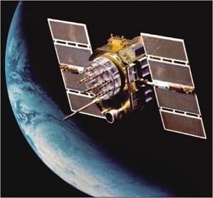
Satellites in orbit
Satellite orbits are generally divided into three categories. There are:
Low Earth Orbits (LEO) from about 150 km to 1500 km.
Medium Altitude Orbits form 1500 to 35800 km
High Altitude Orbits from geo-synchronous altitude 35800 km and beyond.
Satellites in Military Functions
Of the several types of military satellites launched each year, three kinds are most important to the armed forces: i.e. reconnaissance, communication and navigation. Taken together they form part of complete information and warning system.
Surveillance
For performing the worldwide surveillance missions, space-based sensors are the only systems capable of providing continuous and complete coverage. Three surveillance missions are currently performed from the space. These are:
Early Warning. Early warning sensors located in geo-synchronous orbit can provide warning of the intercontinental or submarine launched ballistic missile attack. By sensing the missile height through the atmosphere, such systems add critical minutes to strategic warning and validate information by land-based early warning systems.
Nuclear Detonation. Sensors mounted on satellite can automatically sense nuclear explosions and determine where the detonation occurs, and information essential for strategic strike assessment.
Weather Monitoring. Satellite weather coverage has provided the ability to know about the weather of any point on earth's surface round the clock and forecast the same from weather photographs. Strategic weather information is usually obtained from geo-synchronous satellites while detail tactical weather data (current information on cloud coverage) are best gathered from satellites in low sub-synchronous orbit (an orbit having 90 inclination). Wind and sea state can be invaluable to the tactical commanders in effectively employing his forces.
Reconnaissance
Military reconnaissance is similar to surveillance but focuses on obtaining detailed information of a specific nature. Strategically, space based sensors can observe enemy weapons development, verify compliance to arms limitations treaties and aid in strategic targeting. Tactically, satellites can determine deployments of land, sea and air forces prior to and during armed conflict. Intelligence information gathered from satellites can act as a force multiplier to the commanders. Knowing where the enemy is, how strong he is, and what he is doing will always be the most valuable information the commander can have, and often is the decisive factor in battle.
Military reconnaissance
Military reconnaissance satellites can be divided in to the following:
Photographic Reconnaissance Satellites. Satellites are used for photographic reconnaissance purposes from a low altitude orbit of about 200 km. There are two basic types of photographic reconnaissance mission. These are:
1. Area Surveillance. On area surveillance missions, a large area of interest is scanned for object of potential military interest using a wide-angle low-resolution camera.
2. Close-look Photographic Reconnaissance. For a close look Photographic Reconnaissance, the satellite houses a camera with a high resolution and relatively narrow field of view to re-photograph areas of particular interest during area surveillance mission.
Electronic Reconnaissance Satellites. These are known as ears in the space and carry equipment designed to detect and monitor radio signals generated by the enemy's military activities. Signals originate from military communications between bases from early warning radars, air defence and missile defence radars or from those used from missile control are monitored by these satellites. These satellites help to locate systems producing electromagnetic signals and by analyzing characteristics of the signals, essential data may be found out for planning defence. For this, four receivers are used on four satellites to locate the position of an unknown transmitter on the earth surface. Such missions are suitable from and altitude of about 480-650km.
Ocean Surveillance Satellites. Two types of satellites are used to monitor the oceans; one, the ocean surveillance satellites is used to detect and track military surface ships while the other, the oceanographic satellite, is used to determine various ocean properties. These satellites are normally placed at an altitude of about 500 km.
Early Warning Satellites. Warning time is a factor for defence against any attack. The use of artificial earth satellites can extend this warning time to a great extent by detecting the enemy missile as soon as they are launched. Most military targets emit infrared radiation at varying degrees. Early warning satellites detect military targets by use of sensors sensitive to the infrared radiation.
Use of satellites for communication
Satellites are used extensively for military communication. Military satellites use UHF (9225-3400MHz) and SHF (7.2-8.4GHz) and share these with terrestrial systems and other satellites. The other bands which are used for military satellite communication are 14/11 GHz, 30/20 GHz and 40/60 GHz. the availability of higher frequency bands allow enhanced traffic, increase protection from jamming and lower probability of intercepting transmissions from covert terminals. Satellite communication system has a number of advantage which are being extensively exploited for military applications. They include the following:
a. A single satellite can provide communication coverage over a large geographical area.
b. Satellite transponders have large transmission capacities that enable them to support high data rates.
c. The inherent flexibility has the advantage to control remotely and hence less vulnerable to direct attack.
d. They are physically remote and hence less vulnerable to direct attack.
Advantages offered by satellite borne terminals
In addition to above discussed general advantages, satellite borne tactical terminals offer following additional advantage which make communication through satellites more attractive to the military leaders:
a. They can provide communication in areas where coverage by terrestrial links is inadequate.
b. Mobile terminals allow communication to be rapidly established in areas where facilities are absent or destroyed.
c. They provide a service to mobile, shipboard and air borne terminals which are more reliable than HF terrestrial communications.
d. They surpass the conventional systems and simplify logistics for critical command and control network of serving forces deployed in a combat area.
Anti-jamming techniques
A satellite communication can be jammed on both up and down link. Users by using spread spectrum modulation can suitably overcome jamming. Direct sequence and frequency hopping spread spectrum modulation anti-jamming techniques are suitable for military satellite application.
Satellite navigation
Use of satellite for Navigation has revolutionized the positioning any where on the globe. It offered the advantage of finding the position at any point on the global position at any time. Global Positioning System (GPS) has a significant impact on weapon delivery, accuracy and effectiveness of conventional and nuclear forces in missions.
Conclusion
Satellite technology, which has caused the earth to shrink to the size of a global village will make the ocean ponds. Nations are competing in space and many will join. Use of satellite for surveillance systems to detect, classify, track and target naval unit approaching a nation's sphere of influence politically or economically is becoming very common. Though we may not enter into this technology in the near future but it may well be used against us. Hence, its applications and limitations should be known to all of us in all their dimensions, both strategic and tactical.
This article has been approved by ISPR.


Comments