
Hatirjheel project ignores STP recommendation
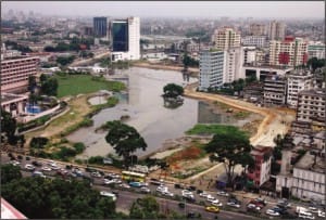
An aerial view of the Hatirjheel canal shows the peripheral road.Photo: STAR
 For all latest news, follow The Daily Star's Google News channel.
 The ongoing Hatirjheel project has been undertaken ignoring recommendation for an elevated roadway in the Strategic Transport Plan (STP), a much cheaper option than the peripheral surface roads being built under the scheme, said experts.
According to the STP recommendation, Panthapath was supposed to be extended up to Rampura Bridge with a high-speed elevated roadway (expressway) with a viaduct (like overpass) over Begunbari and Hatirjheel wetland.
“Elevated roadway would have been a much better option to address the issue of easing east-west traffic loads,” said Dr Rahmatullah, a policy adviser of Transport Sector Management Reform of the Planning Commission.
“It would save huge money required for land acquisition,” he said.
Government has to spend Tk 1100 crore in the ongoing project to acquire about 140 acres of private land on both sides of the water body to build peripheral surface roads.
Transport experts recommended in the World Bank-funded STP for a 3.6-kilometre dual carriageway viaduct for elevated expressway.
STP recommendations are not reflected in the ongoing development project, said Rahmatullah, who worked as an urban transport-planning expert for STP.
East-west link is extremely inadequate in the capital and it is a vital reason for traffic congestion in the city. The elevated roadway was meant to provide a high-speed east-west traffic link, said Rahmatullah.
The government instead undertook a four-lane peripheral ring road scheme under the Hatirjheel Integrated Development Project at a cost of Tk 1,474 crore.
The Executive Committee of the National Economic Council (Ecnec) approved the project on October 8 last year.
The project was aimed at protecting Begunbari and Hatirjheel as flood retention area and establishing an east-west communication to ease perennial waterlogging and traffic congestion problems.
The peripheral roads will not be of the quality of an elevated expressway, said Rahmatullah, adding that it is not going to be helpful for resolving traffic problems.
Simple walkway around Begunbari and Hatirjheel would be enough to prevent encroachment on the wetland, he said.
The government approved the elevated roadway project, stretching between Panthapath and Rampura, on April 5, 2003 as part of the Begunbari-Hatirjheel development project.
The Planning Commission at a meeting on March 4, 2007 decided to carry out study on four areas including traffic, technical, environmental and socio-economic aspects for implementation of the project.
The Japan government granted Tk 300 crore for the elevated road project under debt payment resource of the Japan Bank of International Cooperation (JBIC).
A meeting of the Local Government, Rural Development and Cooperatives (LGRD) ministry on February 12, 2007 decided to take measures to get the elevated roadway project approved by the Ecnec.
But Anwarul Iqbal, adviser to the caretaker government told an inter-ministerial meeting on April 5, 2007 that the Panthapath-Pragati Sarani /Gulshan connecting elevated roadway project had been cancelled by the government.
However, the Japanese fund is being spent in the new project, according to officials.
Professor Mujibur Rahman, leader of the ongoing project's consulting team from Bangladesh University of Engineering and Technology (Buet), said they have tried to incorporate the service of an elevated roadway into the ongoing peripheral road.
“We have not discarded the STP recommendations but altered,” said Prof Rahman. “The peripheral roads have been designed in such a way that they will serve the speedy traffic flow while service roads will cater to the local traffic.”
The same team of Prof Mujibur Rahman carried out a feasibility study of the Begunbari-Hatirjheel development scheme in 2004 and recommended a 3.5-km elevated expressway from Panthapath to Rampura connecting Gulshan Avenue, keeping 265 acres of flood retention plain free of any structures in Begunbari-Hatirjheel area.
“Our team then suggested building elevated roadway to better serve long-distance traffic. We also suggested peripheral roads for local traffic movement,” Prof Mujibur said.
The first study cost Tk 59 lakh while the new study involves around Tk 2 crore.
The Buet team now is designing all three components of the scheme -- peripheral road, development of the entire Hatirjheel area and sewer system.
Gulshan Avenue and Mohakhali-Gulshan link road are going to be connected with the peripheral road at a junction (roundabout) to the south of Taltala Park and west of Police Welfare Trust building at the south end of Gulshan Avenue.
Gulshan Avenue and the link road will have access to the peripheral road.
Prof Mujibur said the project would take a tangible shape by 2010 as set in draft project proposal (DPP) but it would take two to three more years to complete.
The BGMEA building is now within the acquired land of the project, said sources.
There will be a two-way service road stretching between Kazi Nazrul Islam Avenue and Tongi Diversion Road on the southern fringe of the Begunbari canal while there will only be a walkway on the northern fringe (behind Hotel Sonargaon).
Footpath, two-way service road, one-way high-speed road and lakeside walkway will be constructed gradually on both banks of Hatirjheel, starting from Tongi Diversion Road towards Rampura, according to project officials.
Length of the road and footpath will be 11 km. The walkway will be 14 km with a 320-meter long bridge and a 250-meter overpass.
The total project costs of Tk 1473.68 crore includes Tk 1218.68 crore for land acquisition and lake development, Tk 175 crore for peripheral road, Tk 77.97 crore for sewer system and Tk 1.92 crore for Buet study fees.
Engineering brigade of Bangladesh Army is playing the key role in implementation of the entire project.


Comments