
Maritime boundary judgement: A summary glimpse
 For all latest news, follow The Daily Star's Google News channel.
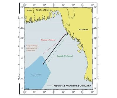
 There seems to be a lot of claims of achievements, counter-claims of failure, and confusion surrounding the outcome of the recent judgement announced by the International Tribunal for the Law of the Sea (ITLOS) on March 14 in Hamburg, Germany. A persistent win-win situation in both Bangladesh and Myanmar may be one of the sources of confusion. The map may give a visual representation of what actually has happened:
The map clearly does not show a winner; however, the text of the judgement indicates a success on the part of Bangladesh in terms of its initiative to resolve a long-standing dispute between parties regarding overlapping claims in an offshore area and an issue that was left unattended since 1974.
The calculations in ITLOS's judgement seem to have apportioned the relevant area by a ratio of approximately 1.54:1 in favour of Myanmar, whose coast facing that area is approximately 1.42 times the length of that of Bangladesh. It delimited the territorial seas of the parties within 12 nautical miles (nm) of their coasts by a line that is equidistant from the nearest points on their coasts (including St. Martin's). The line then continues along a 12nm arc south of St. Martin's to a point equidistant from the nearest points on the mainland coasts of Bangladesh and Myanmar, and proceeds seaward to delimit exclusive economic zones (EEZ) and continental shelves within 200nm of coasts.
The ITLOS also determined that the continental shelves of both countries extended to the continental margin beyond 200nm, and continued the maritime boundary into the area in the same direction.
As reflected in the map, the ITLOS did not agree with many of the arguments presented by both Bangladesh and Myanmar. It did not agree with Myanmar's contention that it does not have jurisdiction to delimit continental shelve beyond 200nm, rather it agreed with Bangladesh that concavity of its coast is of relevance for delimitation. It did not agree with Bangladesh's contention that, by reason of the significant geological discontinuity dividing Burma plate from Indian plate, Myanmar is not entitled to a continental shelve beyond 200nm. The ITLOS concluded that neither the geological origin of the sedimentary deposits nor the junction between the tectonic plates beneath them was legally relevant. Rather, it relied on the existence of a continuous layer of sedimentary rock comprising the continental margin extending seaward from the coast of both countries to the area beyond 200nm to determine the existence of their overlapping entitlements. The line drawn by ITLOS will end when it reaches the maritime boundary with India, whose location is yet to be established.
As for the so-called grey area, the ITLOS decided that in an area of limited size on Bangladesh's side -- beyond 200nm of its EEZ but within the 200nm limit of Myanmar's EEZ -- Bangladesh has jurisdiction with respect to seabed and subsoil of the continental shelf, Myanmar has jurisdiction with respect to the superjacent waters of the EEZ.


Comments