Dhaka in danger

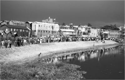
Castles made of sand: Are these houses on land or water? Photo: Amdadul Huq/ drik news
DHAKA is expanding in all directions. The city's master plan, the Dhaka Metropolitan Development Plan (DMDP), has two parts. The Dhaka Structure Plan is valid from 1995-2015, whereas the Urban Area Plan was valid from 1995-2005. The plan considers keeping at least eight flood-flow zones undisturbed -- Dhaka West, DND Triangle, Eastern Fringe polders, Kamrangir Char, Jinjira, Narayanganj West, Dhaka NW, and Narayanganj East.
Unfortunately, this is not happening. Already, unscrupulous developers have filled a number of flood-flow zones, something that Rajuk has failed to prevent (Ferdousi, 2006). Low-lying areas and flood-flow zones are encroached by both public and private sector-initiated housing projects. Flora and fauna are decreasing, cultivable land area is shrinking, and crop production has come down by a considerable amount over the decades (Rahman, 2007).
The city's eastern part regularly goes under water during the rainy season. This part also holds rainwater runoff for a large part of the city through natural drains. During the last decade, about 19 housing projects were initiated in the eastern fringe. It is expected that all housing projects will be implemented in the next 10 years. Most of these estates were developed by filling low land with sand, soil and solid waste.
An analysis of IRS image of 1996 and IRS image of 2000 clearly shows that water bodies measuring about 2,300 sq. metres were filled in during the development of Bashundhara and Bashumoti housing estates. Similarly, for Aftabnagar Housing branches of natural drains and large water bodies, covering an area of 66 acres, were lost due to housing development.
In the southern part of Buriganga river, Rajuk (the capital development authority) initiated a residential project on an area of 381 acres. The project site used to remain under water most of the year. The site is demarcated as a water-retention pond in the Dhaka Master Plan. Over the last two years, this area was filled for a housing development. Apart from this, about 3,000 sq. metres of natural water bodies have already disappeared during the Riverview Housing Estate development on the Buriganga River bank's southern fringe (Rahman, 2007).
In western Dhaka, housing estates were initiated over the last two decades. In 1996, there were 211 acres of water bodies in the Mohammedia housing estate and Adabbor area. During development, about 91 acres of water bodies disappeared between 1996 and 2006 and 68 acres between 2006 and 2009.
Since Dhaka is developing fast, and without proper guidance, we may see more cases like the June 1 Begunbari building collapse -- where buildings are constructed on marshy land -- or during an earthquake where soil liquefaction may devastate the city.
Liquefaction is a physical process of ground failure that takes place during some earthquakes. Because of liquefaction, soft, young, water-saturated, well-sorted, fine grain sands and silt behave as viscous fluids, rather than solids. If pore-space water pressure increases to the point where the soil's shear strength no longer supports the weight of the overlying soil, buildings, roads, houses, etc., then the soil flows like a liquid and causes extensive surface damage.
On September 19, 1985, an earthquake struck Mexico City, with a magnitude of 8.1 on the Richter scale. The earthquake's epicenter was 240 miles from the city. Since Mexico City is situated on land once covered by Lake Texcoco and was filled in for habitation, hundreds of city buildings collapsed due to the heavy shaking of the ground and the quake's long duration, which lasted three to four minutes. Similarly, for the Niigata earthquake and the Alaska earthquake, also of 1964, liquefaction phenomena devastated the cities. Hundreds of buildings collapsed and were damaged due to its affects.
A recent study by Comprehensive Disaster Management Program (CDMP) on the liquefaction susceptibility of Dhaka indicates that the city's eastern and southwestern parts lie within the high to very high liquefaction susceptibility range. These parts are recently filled and developed marshy lands.
The CDMP study also identified several active faults within Bangladesh, based on historical events and evidence from geological investigations. The Madhupur and Dauki faults, about 90 and 230 miles, respectively, from Dhaka, are those identified by experts. The 1985 Mexico City earthquake caused a considerable amount of damage, even though the source was 240 miles from the city.
In Dhaka, an earthquake from either Madhupur or Dauki may cause severe liquefaction effects to buildings, especially those developed on marshy lands on the eastern and western fringes, and even within the city in the infill areas like Begunbari, part of Mirpur etc.
Proper land-use control mechanism is required to ensure Dhaka's future development, considering the possible liquefaction effects of earthquakes. In-depth studies and research in this regard would be helpful for the preparing Dhaka's development in the coming decade.
Md. Anisur Rahman is a Land-Use Planning Specialist, Asian Disaster Preparedness Centre. Email: [email protected].

 For all latest news, follow The Daily Star's Google News channel.


Comments