Narrow Buriganga bend turns deadly

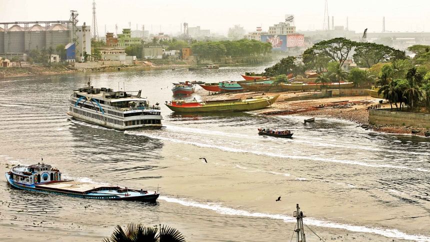
A narrow V-shaped bend in the Buriganga river, one of the major channels of the country's inland waterways communications, has increasingly become an accident-prone zone in recent years.
Frequent riverine accidents of passenger and cargo vessels in this zone, near Narayanganj's Fatullah area, have claimed dozens of lives over the last couple of years.
Passengers and water transport operators said the bend has narrowed over the years due to rampant grabbing of the riverbanks.
At the same time, the number of water transport is increasing day by day and almost all vessels from the capital bound for the southern districts have to pass through the bend.
Moreover, many vessels are kept anchored at the channel and hundreds of sand-laden cargo vessels ply the channel round the clock.
These factors have made the river's bend an accident-prone zone, said Nurul Haque, general secretary of the Bangladesh Cargo Vessel Owners Association.
Environmentalists and vessel operators have demanded widening of the bend by excavating the river banks, after evicting illegal structures.
This narrow point borders Dhaka and Narayanganj districts with Fatullah area of Narayanganj Sadar upazila on the eastern side of the river and Dhaka's Keraniganj upazila to the west.
The Buriganga river from Dhaka's Kamrangirchar area goes straight via Sadarghat and the Postogola area. As the river approaches Fatullah, it takes a V-shaped bend and flows in the south-western direction, eventually connecting with the Dhaleshwari river.
This turning point is the narrowest portion of the waterways between Dhaka and Narayanganj -- as a result, accidents have become commonplace and sometimes even fatal.
MULTIPLE ACCIDENTS IN LAST THREE YEARS
A collision between passenger vessels Kirtonkhola-10 and MV Farhan-10 in January this year, and two accidents involving launches and sand-laden vessels in March last year took place at this point.
Also, at least three passengers died when a sand-carrying vessel sank after collision with a passenger vessel on January 3 last year.
Similar collisions between passenger vessels and sand-laden cargo vessels took place on April 19 and March 10 in 2019 and on January 12, 2018.
A vessel carrying 29 cattle sank after collision with a passenger vessel on August 18, 2018, according to media reports.
"The turning point is very dangerous. When we approach the turning point, we cannot see any vessel coming from the opposite direction. That is why we have to maintain maximum caution as we cross it," said Altaf Hossain, in-charge master of passenger vessel Sundarban-14.
"We have to keep honking while crossing the zone. The channel is so narrow that we often face difficulties in operating our vessel through that point," he told The Daily Star.
Mohammad Ruhul Amin, assistant master of MV Sundarban-10 launch, echoed this, saying the major danger is the narrow turning point, compounded by the fact that many cargo vessels are kept anchored there.
Nurul Haque said, in most cases, owners of sand-laden vessels appoint unskilled drivers who don't have any training to operate these vessels. That is why accidents are occurring frequently, he added.
RIVERBANK GRABBING
Where previously, the Dhaka-Narayanganj highway could be seen easily from the bank of the Buriganga, it now appears distant because most of the land between the river and the highway has been grabbed and illegal structures set up.
On a recent visit, this writer observed a market constructed on the grabbed river land between the highway and Fatullah launch terminal by the Bangladesh Inland Water Transport Authority (BIWTA), a government body.
A weekly cattle market sits every Tuesday on the filled-up portion of the river adjacent to Postogola-Narayanganj highway to the north of Fatullah launch terminal. It, however, has no permanent structure.
Locals said the government authorities have evicted all the illegal structures there. But no step has been taken to re-excavate the riverbank, they added.
The western side of the Buriganga's narrow bend is visibly worse off as multiple dockyards have been set up occupying the riverbank, where vessels are being constructed and others are anchored.
Konda Union Parishad Chairman Muhammad Saidur Rahman Chowdhury, under whose jurisdiction this area lies in Keraniganj's Konda union, said BIWTA set up pillars demarcating the river boundaries and evicted illegal structures.
"But the government authorities are yet to take any measure to excavate the river bank. If the river banks on both sides are excavated, the river channel would be wider and safer," he added.
Contacted, BIWTA Executive Engineer Md Motiul Islam, also Dhaka's Circular Waterway Project's deputy chief director, referred this writer to Md Gulzar Ali, joint director (port and transport) of BIWTA.
Gulzar Ali then referred this writer to BIWTA's joint director (river safety and traffic management) Md Jainal Abedin, who did not respond to multiple calls or text messages.
HC DIRECTIVES IGNORED
Poribesh Bachao Andolon Chairman Abu Naser Khan said the problems of the waterway can be solved if the High Court directives on river boundaries' demarcation are followed properly.
The river channel can be widened if the river bank is excavated on the basis of CS land survey records, he said.
In 2009, the HC's landmark judgement on saving four rivers surrounding Dhaka included directives to demarcate the rivers based on CS records, set boundary pillars, evict grabbers, and dredge the rivers, among others.
When these were ignored and earth and sand filling continued unabatedly, the HC gave another judgement in 2019 which declared all rivers flowing through the country to be living beings and accordingly, legal rights in case of harm.
The HC also directed the government to remove sand and earth if any river land is illegally filled up and that this cost be realised from the occupying party by the government.
"Keeping the river banks unexcavated is similar to living with cancer. There is no alternative to excavating the river bank to ensure a safe river route," said Naser.

 For all latest news, follow The Daily Star's Google News channel.


Comments