Suicidal land loss?
Suicidal land loss?
THE purpose of this article is to argue that the current rate of loss of agricultural land in Bangladesh is no less than 1% per annum. At this rate, if we argue from the probable causes creating such loss, at least 30% of the agricultural land of Bangladesh will be lost over the next 25 years. This is a fact of great importance, second only to the depressing stories of workers who flee abroad in search of jobs and security. The claim of 1% loss was common knowledge until 2012, when on Nov 15, an article in the Daily Star announced that “New study finds 0.3pc of arable land lost each year” . Remarkably, the article does NOT tell us who conducted the study, how it was conducted, and where one could access the new study. This is not how public should be informed.
Measuring land is not intrinsically esoteric. Everyone should be able to follow what is being done. Indeed, credibility requires that policymakers use methods that the public can understand, and accountability is required for the methods used to be replicable by informed citizens. Without credibility and accountability, democratic participatory policies cannot be formed or executed.
Bewilderment: The literature on land loss can leave one confused. We are told that ' 220 ha of arable land is being lost daily', that annual conversion of agricultural land to non-agricultural use is to be 0.56 percent , that the loss of agricultural land in Narshingdi and Narayanganj exceeds one percent per year . The fog that is created at present is not clarified by the multiple statistics one can draw upon from the BBS. For 2008 we have Annual Estimates , Sample Survey, and Census of Agriculture. BBS officials are of the opinion that comparison of data is inappropriate due to differences in methodology, coverage, and purpose in collecting the data in these three cases. How can the interested public possibly sort through this? Fortunately, modern technology offers us a viable option, satellite imagery.
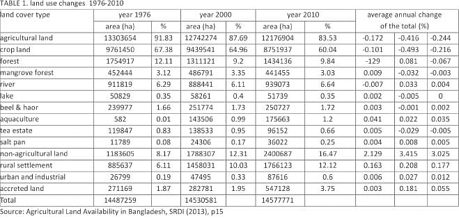
Clarity: Satellite images are the most objective data source we know of for such questions. The images from NASA are not cheap , but for important policy involving food security , they are practically free. Processing the data by the Soil Resource development institute (SRDI) computer takes another 16 hours. At the moment, SRDI uses about 1500 locations to verify its findings, so this is reassuring. Most importantly, if the images are made available to qualified researchers and the media, anyone who has a little time and money can independently verify queries about land and soil, right down to the 'bhita' level, just by using the computer. Table 1 shows the summary results of such analysis.
Since BBS and SRDI differ in significant ways it will be best to treat land loss according to each source separately. BBS data shows us that between 1986 and 1996 crop land was being lost at about 1% per year. BBS data also shows us that the total land area of Bangladesh has increased by 4% between 1948 and 2006. The Table shows that river char, haors etc cannot account for the increase of land, which must arise from recovered coastal land. This clears up the argument. First, the public is correct in pointing out the loss of the agricultural land that they do see—in all settled areas of Bangladesh land is probably being lost at 1%. Secondly, the experts claim is also true--- very few of us see the total crop land because the new lands are remote and coastal. The reader can be left to judge whether any complacency about land loss can be justified on this basis.
Let us focus upon the period between 1986 and 1996 in the BBS data. Land was being lost at 1% to satisfy the need for housing, roads and industries. Have the forces creating a demand for housing, roads or industries lessened since then? Quite the contrary. Economic growth has accelerated somewhat and so has the inflow of remittances. It is only the acquired coastal land that is permitting complacency about the actual loss of crop land. What are the causes of coastal accretion? Are they waxing or waning? This is a more delicate scientific issue, which really does need experts, but no one appears to address this issue in the media.
What about SRDI data? This data clearly shows an acceleration of crop land loss in recent years. It jumped from 13413 ha pa in the 24 years before 2000, to about 68690 ha pa in the decade since---a fivefold increase. If we estimate a point rate of change in 2010 it is about -.8 per cent. Since the data shows an accelerating trend, the rate of land loss in 2014 can be claimed to be 1%.
To conclude, the first point is that the media has to prod the establishment into giving us competent, comprehensible answers. Till this is done, the most reasonable opinion about the policy relevant rate of loss of agricultural land is still 1% per annum---which is alarming. The original article in the Daily Star astonished me, so I immediately queried several economists who should know, ---and got little response. The second point is about our experts. They make carefully guarded statements but never seem to follow up their doubts. Why does every question have to become a 'project'---something to be financed by a donor---before it is carefully studied? Can Bangladesh not build up its own expertise simply because the questions are relevant?
The writer is professor of Economics, Emerites, University of Illinois.