
An alternative to the alternative
As civil society and environmental activists rally against the threat of a fume-belching behemoth a mere 14 kilometres from the Sundarbans, the other two factors holding the Sundarbans in a death vice are being largely ignored in the mainstream discourse against the defiling of a UN World Heritage Site. The Prime Minister's Economic Advisor on September 17 requested scientific basis of the criticism against the coal-fired power plant at Rampal.
About 7000 years ago, sediment-laden freshwater carried from the foothills of the Himalayas by the Ganges River and eventually, the Bhagirathi river and then the Gorai, provided a unique natural balance that allowed a rare species of trees to grow in the Ganges delta – the Sundri. Preferring a balance of freshwater to very low-salinity water - about less than one part per thousand - it became a dominant species of plants and thrived, leading to the formation of the wonderfully diverse, breathtakingly beautiful natural mangrove forest that we call Sundarban.
 For all latest news, follow The Daily Star's Google News channel.
 Since April 1975, India started diverting freshwater from the Ganges away from the Padma, utilising the Farakka Barrage - unlinking the Gorai from the Padma and thereby reducing the sediment-laden freshwater discharge that is so vital for the survival of the Sundarbans. Cut off from the Padma, the Sundarbans faced increasingly intrusive marine water that raised the levels of salinity in the water and land area of the forests (Aziz and Paul 2015, Diversity 7: 242-269), salinity levels well beyond what the Sundri species can tolerate. After about 10 years of Farakka Barrage operation, Chaffey et al. (1985) concluded that much of the Sundarbans no longer provides an environment to which Sundri is ecologically well suited. After nearly 20 years of the operation of Farakka, about 60 percent of the Sundarbans on the Bangladeshi side was converted into a highly saline environment (Karim, 1994, Mangroves of Sundarbans, IUCN) contrary to the 50 percent freshwater characteristic of the northern and moderate salinity in the southern regions in the 1930s (Curtis 1933). As a result, low quality mangroves like the Goran, Gewa, Kewra, etc. invaded the forest at the expense of the pure strand of Sundri (Siddiqi 1994, Natural regeneration. Total growing stocks of 296 per hectare (of which 211 were Sundri trees) in late 1950s (FORESTAL 1960) were reduced to 144 (of which 106 were Sundri trees) in an inventory made by the Department of Forests in 1996.
Salt in the water, salt in the soil – already, the Sundarbans is declining due to rising salinity.
Eventually, with the completion of the Rampal power plant at the currently proposed site, there will be carbon soot in the air released from the plant, blown over to ecologically sensitive Sundarbans plant communities, forming a black, sticky coating on leaves and flowers during dry winter seasons. This will occur despite the usage of USCT filtration technology that will be used at Rampal, which has an efficiency of 40-45 percent, according to experts. The black coating will reduce the plant's carbon fixation and flower formation, increase leaf fall affecting plant growth, and other biota. Fruits and seeds formation will be affected - Sundarbans degradation will be accelerated manifold.
To get affordable power we can't afford to damage the Sundarbans, which provides ecosystem services in various ways. First and foremost is the carbon sequestration provided by the forest reducing the effects of global warming. The total carbon stock of the forest during 2009-10 was estimated to be 55.8 million metric tonnes. If carbon traded Bangladesh could earn a minimum ($5.00 per ton) of US $279 million per year, the carbon deposit would be equivalent to 205 million tonne carbon dioxide sequestration. This value is four times the annual carbon dioxide emission rate of Bangladesh from fossil fuel consumption (Bangladesh Forest Department 2010, Integrated Resources Management plans for Sundarbans). The Sundarbans acts as a natural wall, saving property as well as millions of lives from natural disasters, the value of which is between USD 273 and 714 million (Hussain 2014, Bangladesh Sundarban Delta Vision 2050. IUCN ). Aziz and Paul (2015) noted that recently, many of the cyclones that were supposed to strike Sundarbans changed their routes towards Chittagong, a phenomenon that is most likely due to buffering of the atmosphere around the Sundarbans saving lives and property.
Considering the present need for power in a developing nation and the stance of the government regarding the issue, alternative locations have been suggested. In an interview published in The Daily Star on September 1, Prof. Dr. Badrul Imam of Dhaka University proposed shifting the location of the coal fired power plant 24 kilometres north of the Sundarbans. However, the proposition of relocation presents a few problems.
Freshwater is the lifeline of the Sundarbans and is also vital for the proposed coal power plant. For the last 40 years or so, there has been decreased sediment-laden freshwater flow in the Ganges flood plain, especially through the Gorai River. The Sundarbans is fed with freshwater from Ganges through Gorai. Discharge measured at Gorai railway bridge, over 160 km away from Sundarbans, revealed that minimum monthly availability varies from 0.00 to 170 cubic metres during dry period. Whatever the amount the area gets, more than 50 percent is discharged into the Madhumati River and the rest into the Passur.
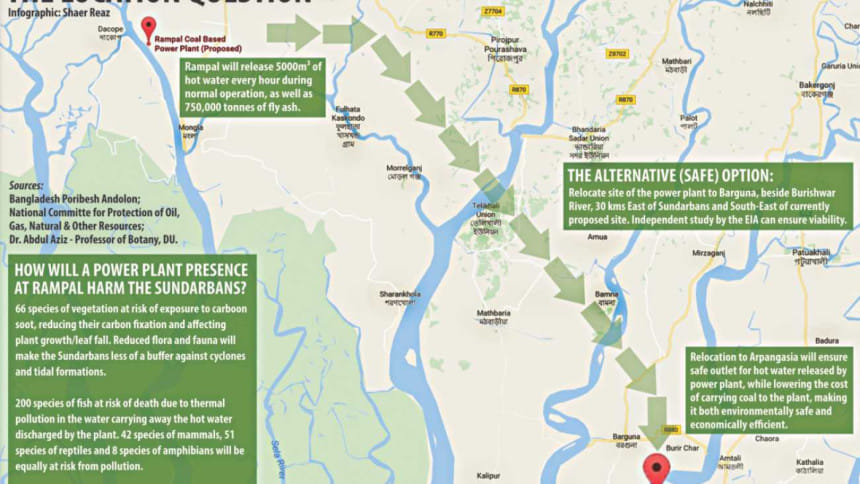
There is little data to suggest how much it is exactly, but enough is known to note that in almost every April or May in the last 40 years, there has been no freshwater supply to the Sundarbans at least for some days or weeks. So with no freshwater pressure from upstream in Lobon Chara or in the Rampal part of the Passur River, neither of these locations will be suitable for establishing the coal-fired plant. The tidal pattern north of the Sundarbans will help in building up heat in the river - where 5000 cubic metres of hot water will be released every hour by the power-plant, and during nip tide, hot water will not move fast enough. By the time high tide starts, the moderately hot water will stagnate – a continuous release of hot water will create thermal pollution, surely killing aquatic biota. Again, at the start of low tide, the thermal polluted water will be quickly carried towards the Sundarbans, jeopardising water and soil environment. The hot water will affect nitrogen fixers, decomposers and more, thus affecting fertility of water and soil, seed germination as well as seedling growth. Phytoplankton death will block the food chain, affecting fish production, death of fish fry, eventually affecting fishers operating in the region. A 15 to 20 kilometre impact zone exists to the north and east of the Sundarban mangrove forest, and human settlements 3.5 million strong, who are partly dependent on the forests, will certainly be affected if the plant is moved to the north.
Considering the scarcity of freshwater discharge during dry periods from upstream into the Passur - thereby leading to stagnation of hot water causing thermal pollution, carrying carbon soot towards south during winter/dry seasons on to the Sundarbans – and the possibility of oil slick from the coal carrying vessels, the coal-fired power plant may be established on the east bank of the Burishwar River. The suggested site is Arpangasia, opposite to Burir Char, Barguna – about 30 km east of the Sundarbans and south east of the currently proposed Rampal site. The Sundarbans will be 30 kms away from north and south wind direction or vice versa, so effects of soot on Sundarbans' plant communities and the other impacts being debated at present will be eliminated, along with reduced thermal pollution in the River Burishwar (since it is much wider than the Rampal area of Passur River, close to the coast and freshwater discharge from Maghna will eliminate the threat of thermal pollution by ensuring no stagnation at any point). The location will also ensure a very low carrying cost of 13,000 metric tonnes of coal every day, so it is also economically viable.
Considering the scientific basis provided in the above arguments for relocation of the site, the government should look into doing a feasibility study at the suggested location of the east bank of the Burishwar River, south-east of the Borguna Sadar, and ensure the survival of a vital asset to the nation and the global climate.
The writer is Professor, Department of Botany, University of Dhaka.


Comments