
Hudhud turns into very severe cyclonic storm
The severe cyclonic storm Hudhud over the West Central Bay and adjoining East Central Bay moved slightly northwestwards and intensified into a very severe cyclonic storm (ecp 984 hpa) over the same area.
High alert on 'Hudhud' sounded along coastal Bengal http://t.co/957F1wgaXw
— dna (@dna) October 9, 2014
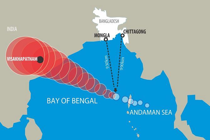
It was centered at 6:00pm today about 975 kms southwest of Chittagong port, 910 kms southwest of Cox’s Bazar port, 880 kms south-southwest of Mongla port and 870 kms south-southwest of Payra port.
It is likely to intensify further and move in a west-northwesterly direction, said a Met office special bulletin.
 For all latest news, follow The Daily Star's Google News channel.
 India is about to face a monster of a storm. Here's my comprehensive forecast update: http://t.co/UKJxEDdBhU #Hudhud pic.twitter.com/Qk4NCteudD
— Eric Holthaus (@EricHolthaus) October 8, 2014
Maximum sustained wind speed within 74 kms of the storm centre is about 120 kph rising to 140 kph in gusts/squalls. Sea will remain very high near the storm centre.
Cyclone named after the state bird of Israel is about to hit India http://t.co/oWEcmfBb7J pic.twitter.com/R0fVX9s6l2
— Mashable (@mashable) October 9, 2014
Under the influence of the very severe cyclonic storm, squally weather may affect the North Bay and the maritime ports.
The maritime ports of Chittagong, Cox’s Bazar, Mongla and Payra have been advised to lower distant warning signal No. 2 but instead hoist local cautionary signal No. 3.
All fishing boats and trawlers over the North Bay have been advised to remain close to the coast and proceed with caution till further notice.


Comments