|
The
City of Peace:
Bolivia
Nabeel
Atique
In
July 2003, I bitten the travel bug once more. This time
it had hit hard. Summer was upon me and I was itching to
go somewhere. Bolivia presented the perfect opportunity
for adventure and exploration. It was a little off the beaten
path, but still had a bit of tourist infrastructure to allow
for relatively safe travel.
On
July 18th I boarded a flight to Miami and was connected
to another flight from Miami to La Paz, one of Bolivia's
capitals. Bolivia's other capital is Sucre (the judicial
capital). The legislative and executive branches lie in
La Paz. Already Bolivia was sounding like a bit of an anomaly!
Two capitals seemed a little unusual. It was the first of
many unusual attributes in the days to come.
The plane landed on the outskirts of La Paz in the city
of El Alto, (The Highest) at 13,300 feet above sea level.
El Alto's airport is the world's highest international airport.
People have been known to collapse at the airport due to
the lack of oxygen, which makes them weak and unable to
carry luggage. Altitude sickness is a common ailment for
a lot of people during their first few days in La Paz. I
descended by taxi to La Paz, a mere thousand feet lower
at 12,000 feet. It was a bright Saturday morning and the
sky was blue with a slight chill in the air. July in South
America is winter. Looming over La Paz are several mountain
ranges or “Cordilleras”. The Cordillera Real (Royal Mountains)
were the most prominent and accessible mountains from La
Paz and they were indeed majestic, peaks of white touching
the blue skies. My blood was pumping -- I was going to venture
into the wild and do some climbing in the Condoriri Massif,
a part of the Cordillera Real.
I
checked in to the Columbus Palace Hotel at $25 a day it
was a steal. It had all the amenities one could ask for:
cable TV (in English), a nice restaurant and clean rooms.
It was right by the football stadium in La Paz. This stadium
is notorious among other South American teams. Being the
highest stadium in the world, Brazilian, Argentine and other
South American football players find themselves gasping
for air and fall victim to the well acclimatised Bolivians.
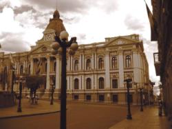
I
was certainly feeling sluggish and the altitude was affecting
me. I decided to take a tour of the city of La Paz and take
it easy for the rest of the day. My guide Mario spoke fairly
good English and he took me on a tour of La Paz's many sites.
La Paz means “The Peace” in Spanish and the name originates
from peace achieved between two warring Spanish groups during
colonial times. The city's most prominent plaza has a statue
of Pedro Domingo Murillo: he was a martyr who was hanged
for proclaiming independence from the Spanish. The plaza
is surrounded by colonial buildings which could make one
think they are in Europe and not South America.
Next,
I was taken to see “La Valle de la Luna” (The Valley of
the Moon). It was a small valley with interesting desolate
rock formations. Behind this valley was the world's highest
golf course. This part of Bolivia is situated on the “
Altiplano” (high plateau) and as a result has some of the
highest things in the world. Among them is the highest ski
lift in the world. The best part of my tour was visiting
the market a colourful experience. You could buy all sorts
of things at very cheap prices. Warm clothes, hats, bags,
slippers, you name it! Also for sale were colourful cases
and bags made of Alpaca wool. Llamas and Alpacas roam the
mountainside here and their wool provides material for all
sorts of items, even sweaters and other warm clothes.
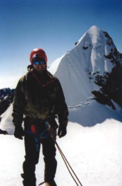
The
next day I met by my climbing guide Branko from Slovenia
at 9 am. He seemed friendly and spoke fairly decent English.
He took out a pack of cigarettes and offered me one. I declined
the cigarette, and watched Branko smoke away as I huffed
and puffed just trying to carry my backpack. I was already
struggling with 40% less oxygen in the air--a cigarette
would probably have knocked me out! Later on Branko told
me he was NOT a professional guide, but worked at a software
company in Slovenia. Great. The adventure was about to begin.
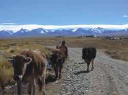
We
picked up Benjamin, a young American and headed to the mountains
in a jeep. The road was heinous and bumpy. But after three
hours of rattling we were at the trailhead at a village
called Tuni, near a lake of the same name. Here we loaded
our gear onto donkeys and started hiking up to our base
camp at 15,500 feet near another lake: Lake Chiarkota. The
donkey herders were young native American women from the
Aymara tribe. In fact, the majority of the people in La
Paz are of Aymara descent. There are some people who are
a mix of Spanish and Aymara.
After
about 3 hours of hiking, the Condoriri Massif came into
view. It was awe-inspiring. It looked just like a Condor
with wings out-stretched. Surrounding the “Condor” were
several other peaks. It is a climber's paradise one can
choose from a variety of climbs, all leading to heights
of about 17,500 feet. We settled into camp at about three
in the afternoon. Benjamin and I shared a tent. We were
resting inside when Branko made an announcement “Guys we
cannot climb”. I thought he was joking around. His look
stayed serious. Apparently Marco, his boss, had failed to
pack his sleeping bag with his gear. Temperatures were already
sub-zero in the afternoon. Branko would freeze at night.
It was an impossible situation. Branko looked helpless.
I offered him my down jacket and Benjamin offered him his
sleeping bag (what would Ben do?). Benjamin and I were certainly
not up to quitting because Branko (or Marco) forgot the
guide's sleeping bag.
Branko
borrowed Alberto's sleeping bag. Alberto was our cook. He
was an older Aymara man. A month ago Alberto had lost his
son Vincente to the mountains. Vincente was guiding two
North American diplomats up a mountain. One of the team
slipped and the three of them fell to their deaths. After
such a tragedy, Alberto was still on the mountain doing
his job. Life is hard for the Aymara and they have to make
a living. There is little time for mourning in this harsh
existence. The Altiplano (High Plateau) is a far cry from
the relaxed sea-side resorts of Chile. I never saw anyone
enjoying a siesta in the afternoon in these parts.
It
was soon dinner time. The first course was soup with the
special Bolivian freeze-dried potatoes. The potatoes are
boiled and stuck in the ground for several days. After that
they can be eaten for years. The soup was excellent. I had
made a request to exclude pork from the diet, while on the
mountain. We were served spaghetti with red meat. No one
was able to tell me what the meat actually was. It didn't
look too appetising, as I watched Branko scarf it down.
Ben took a spoonful and his face turned pale. I nibbled
on a string of spaghetti and decided I would pass. I filled
myself on bread and soup. I would lose a few pounds on this
trip. Ben got diarrhoea from the food.
The
wind howled most of the night. Temperatures plummeted. I
barely slept. The altitude, lack of food and noise from
the tempest outside kept me up. At 4:30 am Branko stopped
by to tell us to get ready. I had some oatmeal and tea,
layered up in the usual warm clothes, strapped my harness,
helmet and headlamp on and we were off. We hiked up a moraine
for about an hour and we were at the base of the Tarija
Glacier. The glacier looked ominous. It looked like a mammoth
slab of ice from the ice-age. Early rays of the sun were
reflecting off it, displaying its icy nature. I strapped
on my crampons and with ice-axe in hand, roped together
we marched onto the glacier. The ice was so hard that my
ice-axe would not penetrate at all. It merely served as
a walking stick at this point. We crossed several crevasses
and made our way up carefully. Every now and then we'd stop
to catch our breaths. Branko wasn't challenged enough, so
he would have a cigarette at each and every break. Now,
when I think of the “Marlboro Man”, Branko comes to mind.
Complete with cowboy hat and an unshaved face.
At
about noon we were on top of a small plateau. To reach the
plateau we had to cross a gaping crevasse that was at an
angle. I pretty much had to high-dagger the axe and pull
and jump at the same time it was thrilling. We had another
30 feet of a steep exposed ridge and we'd be at the summit
of Tarija. Branko, to his credit, set up a belay for us
and showed signs of caution and safety (that any qualified
guide should have). We were on Tarija at last. The views
were incredible. Of all the mountains surrounding us, Pequeno
Alpamayo stole the limelight and its steep pyramid looked
magnificent. A condor was flying above and cast its shadow
on the entire mountain. It was a perfect view from a successful
summit. It was also a reminder to get down safely. I had
no plans of becoming dinner for the condor!
The
descent was trickier. We had to jump some crevasses and
the ice on the glacier had started to melt with the rising
sun. Water was trickling down and gave me an unnerving feeling.
We were safely back in camp at about 4pm. Dinner that night
was a welcome meal of trout and rice, which I enjoyed thoroughly.
We were told that the trout had been fished out of Lake
Chiarkota, next to our camp. The next day we hiked back
to Tuni and were driven to La Paz.
The
next few days were spent in Bolivia seeing sights and travelling
around. My first stop was Lake Titicaca. At an altitude
of 12,500 feet it is one of the largest and highest navigable
lakes in the world. I took a speed boat ride in the lake
and visited an island in the middle of the lake Suriqui
Island. The island is famous for its his tory of boat construction.
The famous Norwegian expeditioner Thor Heyerdahl came all
the way to Bolivia to construct some of his expedition vessels.
From Suriqui, I saw beautiful views across to Peru. I was
followed around by two Aymara kids Wilson and Sylvia. They
were trying to get me to buy miniature llamas. Wendy my
guide, I and the two kids walked around the island. In the
end I bought a llama. I also posed for photos with the kids
and other kids joined in. Off course, it was purely a business
transaction and the kids all got paid until I ran out of
coins!
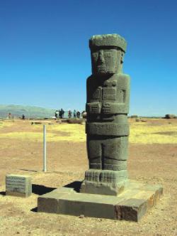
The
next day I went to see the ancient ruins of Tiawanaku. I
had no previous knowledge about this and it was a nice surprise
to find pre-Inca ruins only a couple of hours away from
La Paz. The Tiawanaku civilisation dates back to about 2000
years and displayed a budding civilisation complete with
stone architecture (including pyramids) and tools, pottery
and huge monoliths. Unfortunately the civilisation did not
last because of droughts that shrunk Lake Titicaca to its
present size and location.
El
Camino de La Muerte (The Road of the Dead). This is
the name aptly given to an 80km long stretch of road from
La Paz to Coroico. The moniker refers to about 25 accidents
every year where a vehicle plummets off the road for about
three thousand feet, killing most passengers. The Inter-American
Bank has labeled this road as the World's Most Dangerous
Road. Amongst all this hype, what's lost is the actual beauty
and amazing scenery of the surroundings. I decided to mountain
bike down this road at least I would be under my own control
and it would make for a thrilling downhill about 11,000
feet. The downhill begins at 15,500 feet at a high mountain
pass called La Cumbre. It was snowing at the top and I was
wearing 4 layers to keep warm including my mountaineering
jacket. Luckily I had brought a full-fingered pair of gloves
and my new Alpaca hat. We sped down the slick road with
a guide up front and a guide in the back. There were nine
of us and two guides. We were followed by a support bus
with spare bikes. Very soon two riders had had enough of
the cold and wet and they decided to pack it up and ride
the bus down. The rest of us stuck with it, and it was worth
every foot of the descent.
From
desert-like passes, we descended into lush tropical forests
with steaming waterfalls. The road had turned to dirt early
on and the ride was muddy and I felt quite at home having
eaten mud many times on my local rides. I was completely
drenched. The climate was warmer down here and the views
were astounding. I could see the narrow road, winding away
into oblivion, cut into the side of this mammoth mountain,
lush with vegetation. One had to be careful about approaching
vehicles and we'd stop or slow down to let the vehicle pass.
Usually there is only room for one vehicle to pass. So,
when two vehicles come face to face, it is quite a predicament
and no doubt, many of the accidents occur then.
From
15,500 feet we reached Yolossa at 4,500 feet. Lunch was
a welcome treat there. Interestingly enough, the ethnicity
of the locals had changed somewhat. At Yolossa I caught
my first glimpse of people of African decent. They were
brought as slaves to work at the silver mines in Potosi,
but had escaped to the tropical forests of the Yungus. Here
they found a climate more favourable and similar to the
home that had been stolen from them. I was told by my tour
operator that I would be provided transportation to Coroico
a resort town in the hills. I was placed in the back of
a truck with local Aymaras and a Korean tourist. Sometimes
I stood and sometimes I sat, but when it started to rain
they pulled a blue tarp over us and I sat huddled next to
an old Aymara lady and her bundle.
I
was in Coroico in about half an hour and found my hostel:
“Hostal Kory” within minutes. Coroico is very small and
everything is within a few minutes walking distance. I met
Migel there and he took me to my room on the 3rd floor.
I had a room with windows on three sides and my own bathroom.
All for a whopping $8 a night! The views into the valley
of the Yungus were simply amazing. Green forests clouded
in mist. It rained on and off (mostly on) the next day and
I enjoyed kicking back, sleeping in, and walking around
with my new $2 umbrella.
The
day I was to leave the sun came out and I took a guided
tour of some waterfalls by jeep. Carmelo my guide was very
enthusiastic and showed me how coffee beans are extracted
from the trees and showed me legal coca plantations from
which coca leaves are taken to make tea. They are grown
on terraced hillsides. Also grown in the Yungus are bananas,
oranges and sugarcane.
The
bus ride back was nerve-wrecking. But our driver was cautious,
and we arrived safely back in La Paz at about 3:30 pm. I
went for a walk around La Paz and felt sad at having to
leave. Bolivia was South America in its most primitive form.
Bolivia is one of those magical places that draws you back
again and again. For me, the seed had been planted …
|