
Green Plot Ratio: Environmental planning of cities
 For all latest news, follow The Daily Star's Google News channel.
 Weeks ago I went through the article 'Blazing Dhaka: An urban heat island' written by one of my departmental fellows in The Daily Star. It should undoubtedly be a great concern for the urban experts. The UHI is the worse outcome of urban metabolism process (exchange and transformation of material and energy flow) and is very much explicit in most of the densely built urban environments. But most of the economically developed countries are totally dependent on artificial air cooling system to get rid of the uncomfortable local climatic situation which again discharges waste energy in the atmosphere attributing to the global warming. Dhaka, unless address and takes proper initiatives to attenuate the impact of UHI, the city life will be really very much miserable and not unlikely that the city becomes abandoned while also facing other environmental issues as majority of city dwellers are not so rich to own AC and AC in every house in congested localities simply unbearable environmentally.
In this article such a tool has been discussed which can be used as a very strong indicator for greening the urban development. This is not to mention that there are several benefits in increasing the amount of greenery in citiesenvironmentally, aesthetically, and recreationally. From supplying oxygen, food and most of the necessary commodities the extent of services rendered by the plants and trees are multifold: pollution control, heat reduction, ecological habitat restoration, increasing scenic beauty etc. Diverse researches are being carried out to integrate environmental and ecological thinking in urban architecture and design to improve local climatic situation in terms of temperature reduction and attenuating the effect of UHI as well as conserve the existing greenery or compensate the green loss by culturing green above the ground.
Whitford et.al (2001) identified four performance indicators also linked with green spaces: climate, hydrology, carbon storage and sequestration, and biodiversity. The above strategic and multi-dimensional usefulness of greenery in urban built environment called for using a common metrix that can be used as a sustainable indicator for urban design. Therefore, based on the famous planning tool namely, Building Plot Ratio (in our country which is used as Floor Area Ratio) and a biological parameter named Leaf Area Index (LAI), the tool called Green Plot Ratio(GPR), developed and successfully used in many urban designs by a famous landscape architect of Singapore, Dr. Ong Boon Lay who is also a faculty of National University of Singapore.
Building Plot Ratio is just a simple measurement of maximum allowable building development on a site; usually this tool is used to regulate building heights as well as zoning during master planning phase of any area. A site with a BPR of 2:1 can have a building that has a total useable
floor area twice that of the site. The distribution of this floor area can be in the form of a two storey high building which covers the site entirely, a building that is four-storey high which covers only half of the site, or combinations of different arrangements. As the site coverage reduces, the building can be taller and have additional floors therefore the building density is also likely to be increased.
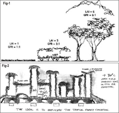
In biological science, LAI is defined as the single-side leaf area per unit ground area. It is a dimensionless number, with many other uses that is vigorously used to predict the plant metabolic processes e.g. photosynthesis, evapotranspiration, respiration and uptake of mineral from the air and ground, the most benefits which we gain from plants. Dry deposition of pollutants and particulates are also dependent on the total leaf area of the plant and its leaf characteristics. For better understanding, LAI can be considered simply as the ratio of leaves to ground covered. GPR is defined as the average LAI of the greenery on the site.
GPR is defined as the average LAI of different plants and also can be defined in the similar way as the ratio of the single-side leaf area of the planted landscape to the plot or site area. The LAI value is determined in terms of the total surface area of leaves of a particular group of plants exposed to the sun as well as ability to tap the transmitted light through the upper layer of translucent leaves. Considering the above criteria and based on previous research data Dr. Boon Lay suggested the value of LAI for grass, bushes and matured trees of dense canopy as respectively, 1, 3 and 6 to 10; the last figures dependent on the density of the matured trees e.g. the density of matured trees varying from dense natural forest to planted matured trees. Therefore one piece of land when covered with grass, corresponding GPR would be 1:1, for bush/shrub or matured trees this would be 3:1 and 6:1 to 10:1;
These values are very much helpful in determining to compensate the amount of green loss due to new development. Suppose, a new mixed development has been proposed in an area which is naturally vegetated and a portion of that vegetation may undergo destruction during development. So we can easily estimate how much LAI we are losing and how we can compensate by planning plantation in the form of vertical gardening, roof gardening and re-plantation.
For example, for the proposed development on an area of 500 SqM , 30 SqM of grass land, 50 SqM of shrub land and 20 SqM of matured tree are needed to be destroyed so during planning phase we can compensate the loss by intellectual design in the form of allocating green provision on the building top, wall, vacant place or maintaining green patches within buildings like park connector or greenways planning and in these way even more GPR or LAI can be achieved than the existing. But it is true that the compensated green will not be same like the existing one in terms of its ecological values and services. Because at the roof level the maximum LAI value of 3 (shrub, bush) (Fig-1) can be achieved and cripplers that are used as the vertical gardening or roof gardening replicate grassland.
Again in a virgin land another type of green patches may exist which is called 'scrubland' that is interspaced with shrub, grass and matured trees, in that case the calculation of GPR depends on the local condition and the planners' sense. So based on GPR calculation in an urban planning a proposed urban built area may be like Fig-2 which is solely depend on the intelligent architecture and design.
A new termskygardenhas been introduced to refer to planted landscapes built above the ground: in intermediate floors of high-rise buildings or at the rooftop. It is true that a roof garden cannot be equivalent to a similar sized garden on the ground as well as a high-rise building wrapped with green cripplers on its roof facades may not be effective as a mature tree of similar size that is lost due to the development but in face of fast urbanization and consequent loss of natural vegetated green lands achieving high GPR in the above form undoubtedly will contribute to a large extent to reduce the effect of habitation loss, worse environmental effect etc.
Therefore rather than looking for modern technologies to combat the effects of climate change or global warming significant concentration should be put on enlightening ideas and innovations regarding green revolution in the architecture and planning starting from an individual building scale to a city scale.


Comments