
Bengal Delta not sinking at a very high rate
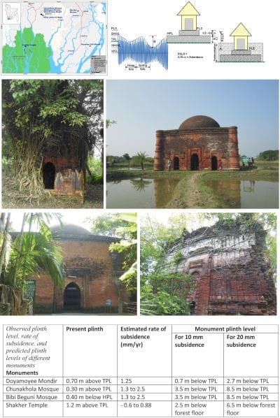
clockwise from top left: Figure 2 : Locations of visited archaeological monuments; Figure 1: Schematic diagram showing the methodology of calculating RSLR using the plinth height of archaeological monuments; Chunakhola Mosque; Shakher Temple; Bibi Beguni Mosque; Doyamayee Kali Mondir
 For all latest news, follow The Daily Star's Google News channel.
 During the last couple of years, several research and
studies have been carried out on the Bengal delta, which suggest that it is subsiding at a very high rate from one to two centimeters per year (cm/yr). In many cases, however, this phenomenon includes subsidence plus Global Sea Level Rise (GSLR), which is generally known as Relative Sea Level Rise (RSLR). Syvitski and his co-researchers published an article in the Nature Geo-science in 2009 where they estimated the rate of RSLR for the different deltas in the world using high resolution satellite images, Shuttle Radar Topography Mission (SRTM) and historical maps.
Syvitski et al. (2009) claimed that due to human interventions, such as groundwater extraction and carbon mining, many of the deltas are sinking at a very high rate. Through their analyses, they assigned a range of 8 to 18 millimeters/yr RSLR for the Ganges-Brahmaputra delta, but did not use any ground truthing information. In our delta, especially in the southern part, which is very much vulnerable to climate change, there is almost no groundwater or carbon mining, which suggests that this RSLR might be a part of a long-term natural sinking process.
Two studies were carried out recently in Bangladesh for two projects in the Ganges-Brahmaputra delta area funded by the World Bank. The studies, however, referred the study by Syvitski et al. (2009) as supporting evidence. One study is on the Sunderbans, carried out by an Expatriate Professor where he showed that the southwest part of the delta was subsiding at the rate of 20 mm/yr. According to him, GSLR is not required to sink the delta; subsidence alone can make it happen within a timeframe of a few decades. Another study, carried out by the Coastal Embankment Improvement Project (CEIP) estimated the rate of subsidence as one cm/yr referring to the recent research carried out through a joint collaboration between Dhaka University and Colorado University, US.
The Geological Department of Dhaka University with the help of their expatriate partners established earth observatory stations at different locations in Bangladesh. They are using stationary GPS (Global Positioning System) reading for calculating both horizontal and vertical earth surface movements. Results from their observations suggest that local subsidence is about 10 mm/yr in Khulna and Patuakhali, although the period of observation is short. More research is being carried out on the same issue from US based universities. The preliminary findings of such research also suggest that the annual sedimentation rate in the Sunderbans is within a centimeter per year, which is also synonymous to RSLR.
The results of such research have long-term implications for Bangladesh. It has become crucial for local people, local investors, decision makers and also the donors in decision making, to find out whether the inhabitants will be encouraged to migrate to other places from the disaster prone delta area or invest huge money to rescue the delta.
Many of the researches are based on remotely sensed data such as satellite images or GPS, or data of the shorter time-scale (one to two years sedimentation rate). The observations from the shorter period may be biased by short-term perturbation and may not be representative of the prevailing decade or century scale processes. It is very difficult to measure the RSLR directly and there are several ways to do so indirectly. Every type of measurement has its limitations. We selected the archaeological monuments in the tidal plains for assessing the rate of RSLR, which can provide a very good indication about the range of subsidence for quite a longer period than reflecting short-term perturbations.
In the tidal plain, land formation occurs by sediment dispersal through tide. The surface level of land is determined by the high tide level, availability of sediment and proximity of tidal rivers/creeks. In natural condition, as in the Sunderbans, most of the land surface is above the average high tide level during neap tide (NHWL) and below the average high tide level during spring tide (SHWL), i.e. land surface level is largely determined by the Mean Sea Level (MSL) and tidal amplitudes. The Global Sea Level is not constant, rather it is changing continuously. Several researches have estimated the Global Sea Level Rise of last 130 years at about 0.2 m. There are no reliable measurements for the past and thus we assumed 0.25 m GSLR for the past few centuries.
Generally there are common practices in building houses or any other structure in tidal plains. Homestead platform is built a few decimeters above the tidal plain, which should be very close to the SHWL, so that the platform is seldom inundated by tidal flooding. The height of the plinth of the houses generally varies from 0.5 to 0.8 m from the house platform level. A simplified diagram is shown in Figure 1 to demonstrate the relation between the tide, tidal plain, homestead platform and plinth levels.
Thus PLS ~ TPL + 1.2 to 1.8 m
RSLR is calculated for lower and higher limits.
Lower RSLR = TPL + 1.2 PLE and Higher RSLR = TPL + 1.8 -PLE
Here SHWL = Spring Tide High Water Level, NHWL = Neap Tide High Water Level, TPL = Tidal Plain Level, HPL = Homestead Platform Level, PLS = Plinth Level Standard, PLE = Plinth Level Existing. Subsidence is calculated after deducting 0.25 m from the calculated RSLR.
Recently, a team from CEGIS visited several archaeological monuments in the southwest region of Bangladesh, the locations of which are shown in Figure 2. The objectives of the visits were to inspect the conditions of different archaeological monuments and to measure the existing plinth heights of the old structures from the tidal plain, homestead platform, or from other reference levels. Information on monuments such as Doyamoyee Mondir, Chunakhola Mosque and Bibi Beguni Mosque and Shakher Temple in the Sunderbans, was used for calculating the rate of subsidence in the Bengal Delta. The Shat Gombuj Mosque and the tomb of Khan Jahan Ali at Bagerhat were not considered as they are constructed on land artificially raised by earth excavated from a huge adjacent pond (dighi).
Brief descriptions based on the Internet and records from the Archaeological Department of Bangladesh are given below. The Plinth levels of these monuments were measured from information on tidal plains, homesteads, or from any other references. In cases of high subsidence like 10 or 20 mm per year, probable elevations of the plinth of those monuments were estimated and compared with the present conditions.
Doyamayee Kali Mondir: The Doyamayee Mondir was built in the year 1208 of the Bengali calendar. It is a temple of the god Shiva and the goddess Kali of the Hindu religion, and is an ancient structure and archaeological heritage. It is located at the side of a tidal creek called Kamlakanto Khal at Galachipa upazila under Patuakhali district. The structure is under the threat of riverbank erosion and a part of the structure has been eroded by the river. It is located on the tidal plain and is free from the effects of poldering. The plinth level of the structure is about 0.7 m above the existing ground/homestead level and 0.5 m below the polder embankment level. During the last 200 years, GSLR has been about 0.25 m and thus the subsidence has been 0.5 0.25 m = 0.25 m. The annual rate of subsidence has not been more than 1.25 mm/yr. If the RSML was 10 mm or 20 mm per year, the plinth level would have been 0.5 m or 2.5 m below the TPL respectively, which is far from the reality.
Chunakhola Mosque: Built in the 15th century, the Chunakhola Mosque is located in the village of Chuna Khola in Bagerhat, and is an archaeological heritage. It has a hemispherical dome with frontal arches. The brick walls were repaired in the 1980s. The plinth level of the mosque is about 0.3 m above the TPL. Thus, the RSLR value during the last 500 years would have been within the range of 0.9 to 1.5 m and hence subsidence would have been 0.65 1.25 m. Therefore, the rate of subsidence would have been 1.3 to 2.5 mm/yr. In this subsidence, settlement due to the massive brick walls with 2.08 m thickness is included. For 10 to 20 mm RSML, the plinth would have been 3.5 m to 8.5 m below the TPL, which cannot be imagined even for any archaeological monument in our tidal plain.
Bibi Beguni Mosque: The single domed Bibi Beguni Mosque was also built in the 15th century and is situated in the west of the Shat Gombuj Mosque. It is square in shape at its outer side. There are three arched doorways in its eastern wall and one each on the north and the south. The plinth is raised, for which the main door height is found to be lower than the Chunakhola Mosque. The level of the original plinth was estimated by comparing the door heights, which are 0.40 m below the homestead level. Thus, the RSML is within 0.9 to 1.5 m and subsequent subsidence is within the range of 0.65 to 1.25 m. The equivalent rate for the age of 500 years is 1.3 to 2.5 mm/yr, almost the same as that of the Chunakhola Mosque.
Shakher Temple: The only standing ancient structure in the Sundarbans is located in Shakher Tek, about one kilometer away from the east bank of the Sibsa River. In the early 17th century, Raja Paratapaditya had established a township and a fort there during his reign in order to fend off Arakanese and Portuguese pirates. The temple itself was built by the Pratapaditya settlers. It is located in Dacope upazila of Khulna district. Made of brickwork, the temple is a temple for the goddess Kali of the Hindu religion.
It is the place where the forest floor level (or TPL) is determined by the undisrupted nature. The plinth level of the structure is about 1.2 m above the forest floor. Thus, the RSML at this location would have been within a range of 0.0 m and 0.6 m and the corresponding subsidence would have been within the range of 0.25 m and 0. 35 m. For this four hundred years old structure, the rate of subsidence thus varied from 0.6 to 0.88 mm/yr. For an RSML of 10 to 20 mm/yr, the plinth of the temple would have been 2.5 m to 6.5 m below the forest floor level.
The estimated rates of subsidence for the four monuments are presented in the accompanying matrix. Likely annual rate of subsidence varies from 0.4 to 1.9 mm/yr, with hardly 1 mm/yr to be added or deducted. If the rate of subsidence would be 10 mm/yr or 20 mm/yr, plinth levels of these monuments could be 0.7 to 8.5 m below the TPL, which are far from our observations. It can be concluded with higher confidence that the rate of subsidence or RSLR in the Bengal Delta is within the range of a few mm/yr and not one to two cm/yr.


Comments