
Human ecology, changing climate and hydrology
 For all latest news, follow The Daily Star's Google News channel.
 Human ecology inquires into the pattern and process of interaction of human with environment. Human values, health, life-style, consumption, wastage, etc. are influenced by physical and biotic environments. Physical environment includes land, air, water, natural resources, construction and infrastructures. On the other hand, living things like plants, seaweeds, animals and organisms constitute biotic environment. The changes in physical environment has been changing climate and hydrology, which has influences on biotic components and subsequently on food supply and living condition of human being.
Extreme temperatures, irregular rainfall, frequent flooding, cyclone and other natural disasters are the facet of climate change. Bangladesh has been warmed up by 0.5°C over the last century, says a report of the Bangladesh Unnayan Parishad (BUP). The data of Compendium of Environmental Statistics 2009 shows that mean temperature of the country was 26°C during 1990s with a variation in maximum temperature between 32°C and 41°C. Meanwhile, maximum temperature reached 46°C with a fall in the minimum to 6°C. The surface temperature is projected to rise by 1.3°C with a seasonal variation of 1.4°C in winter and 0.7°C in summer months by the year 2030.
Rainfall and upstream flow account for 24% and 74%, respectively, of total water resources of the country. Mean annual rainfall over last few years was 2.54 meters of which 81% occurred during wet (May October) season and 19% during dry (November April) season. Bangladesh has 250 big and small rivers but upstream flow in the critical month of March accounts for only 1% of total flows. A major human intervention is the Farakka barrage on the Ganges river in West Bengal, India that diverts upstream flow. The Farakka has become a threat to surface water for the south-west part of Bangladesh. Moreover, forecasts by government and international agencies say that the rainfall in dry season may fall by 37% by the year 2050, which will result in a rise of drought risk.
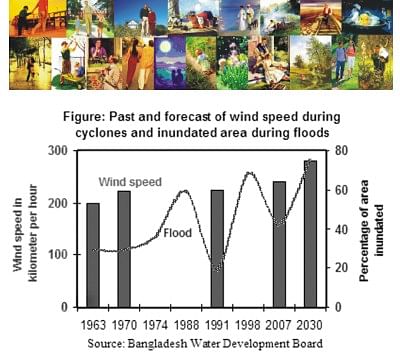
Meanwhile, the United Nations Development Programme (UNDP) identified Bangladesh as the sixth most vulnerable country to floods and the most vulnerable to cyclones. Statistics of the Bangladesh Water Development Board (BWDB) reveals that wind speed during major cyclones and area inundated during major floods increased over the second half of the last century. Huge upstream flows through 57 trans-boundary rivers along with high internal rainfall create a widespread inundation during wet season. The Ganges, Brahmaputra and Meghna are the major rivers with upstream flows. The GBM river system carries about 1.7 billion tons of silts per year. Deposition of silts raising the river bed is a common feature of our river system. Thus lower conveyance capacity of rivers will inevitably increase flooding where monsoon rainfall is estimated to increase by 28% by the year 2050.
Another remarkable feature is the increase in number of natural disasters including floods, draughts and cyclones. Incidences of natural disasters increased from 6 in 1976 to 10 in 1982 to 12 in 1994 to 14 in 2000 as per the data of the Centre for Research on the Epidemiology of Disasters, Brussels. In addition, sea level rise and saline water intrusion have appeared as a natural disaster in coastal areas. The BUP reported that the sea level in the Bay of Bengal rose by 0.5 meters over the last century. A World Bank study reveals that about 15% to 17% of the country's land area i.e. 22,135 to 26,562 square kilometers of coastal land will be submerged due to 1.0 meter rise in sea level within the next 100 years. The Ministry of Environment and Forestry has identified the submerging of low lying coastal land together with saline water intrusion as the crucial issue for this land-scarce country.
Country's ever growing population has created demand for food, which has intensified human intervention in the form of deforestation, mechanization of irrigation, construction of dams and barrages, etc. Rice is the single dominated crop, farming of which expanded with high yielding varieties (HYV) under irrigated condition. Meanwhile, the proportion of groundwater to total irrigation increased from 15% to 73% during 1979-2005. Regrettably, availability of renewable surface water, which is estimated to be 1,160 million cubic kilometers, has declined over time. However, rice production increased from 9 million tons in 1975 to 34 million tons in 2010, of which 55% was produced in dry season. The requirement will be 45 million tons for 190 million people in 2030. Upcoming higher pressure on groundwater is a severe problem concerning food production in the country.
Livelihoods of people are much affected by riverbank erosion. Out of total 2,400 kilometers (km) of bank line, every year about 1,200 km is actively eroded and more than 500 km face severe problems related to erosion. A campaign brief of the Equity and Justice Working Group reported that the GBM river system lost 106,300 ha during 1982 and 1992. The erosion rate has gradually increased, which makes a net loss of 8,700 ha per year. An ISPAN study added that a total of 728,439 people were displaced by riverbank erosion during 1981-1993, at an annual rate of 63,722. Another recent study estimated that about one million people become affected by riverbank erosion every year.
Besides riverbank erosion, cyclones and coastal inundation are responsible for loss of homesteads in and migration from coastal region. Yet a large majority of affected people could not overcome the damages of cyclones Sidr of 2007 and Aila of 2009. Many people are suspected to have migrated to distant places as reflected from the preliminary report of the Population Census 2011. The unadjusted census data shows an average annual growth rate of 1.34% during 2001-2011. However, the rate is very low for costal divisions with its value of zero percent for Barishal and 0.6% for Khulna. At present the country has about four million homeless people passing floating life. The World Bank study reveals that a total of 20 million people will be environmental refugees within next 100 years.
Other than food and shelter, human being is affected also in health and livelihood. Heat waves due to extreme temperature will increase the possibility of heat stroke, cardiovascular and respiratory diseases. In addition, prolonged floods will lead to outbreak of water-borne diseases like cholera and diarrhea. Drying up of rivers and upping of river beds have reduced the capture fishery, which has negative impact on livelihoods of fishermen. Moreover, sedimentation and excessive salinity have threatened the world's biggest mangrove forest Sunderbans.
Apparently, water table is going down for excessive withdrawal of groundwater for rice farming in dry season. In terms of water consumption, rice production requires at least 1900 liters per kg whereas vegetables and potato require 300 to 500 liters per kg. Time has come to create social awareness to change food habit from excessive consumption of rice (now 205 kg /head /year) to more of potato and vegetables for better health, too.
Allegedly, upstream flow of Ganges River declined at post-Farakka age. The data of Bangladesh Bureau of Statistics shows that minimum water flow at Hardinge Bridge point was 857 cubic meters per second (cms) in 1987, 786 cms in 1999 and 472 cms in 2007 under India-Bangladesh water sharing treaty, and was the lowest at 267 cms in 1994 without agreement. Upstream flow has become a bit better during lean period after re-agreement in 1996. Available literature states that such intervention has negative impact on the upper and lower river basin in India, too.
Meanwhile, the government has prepared the Bangladesh Climate Change Strategy and Action Plan with emphasis on water security, disaster management, food security and climate resilient cropping system. The country is expected to receive $100 million from donor agencies for Bangladesh Climate Change Resilience Fund to combat risk of climate change. Proper accumulation and transparent utilization of fund is a challenge for the country. Very recently, the government has planned to formulate "The Bangladesh Delta Plan 2100" to address the country's climate change related issues of water security, food production, river erosion, saline water intrusion and ecological problems. In this regard, meaningful planning along with negotiations with India is crucial to keep minimum intervention into natural laws.


Comments