
Are cyclones formed in the Bay different?
IN general, tropical cyclone formation areas of the world are divided into seven basins in which North Indian Ocean is one of them. It has two wings, the Arabian Sea and the Bay of Bengal. According to global cyclone statistics, only 7% of tropical cyclones occur in the North Indian Ocean, but five to six times as many occur in the Bay of Bengal as in the Arabian Sea. By names, Gonu (June 2007) and Phet (May 2010) in the Arabian Sea and Sidr (November 2007), Nargis (April 2008), Giri (October 2010) and Phailin (October 2013) in the Bay of Bengal are recent strong, destructive storms that occurred in the North Indian Ocean. Cyclones occurring in the funnel-shaped Bay of Bengal are particularly deadly, because they often cause severe flooding of the densely populated low-lying coasts of Bangladesh, India, and Myanmar.
At first, I would like to put in plain words what tropical cyclones mean and when or what location they form. Tropical cyclone, also named as typhoon or hurricane (depending on location), is an intense rotating system characterized by strong winds that spiral cyclonically (anticlockwise) around the low-pressure centre. Tropical cyclone is formed only when the surface wind speeds is at least 62 km/hr (34 knot), before that it is called a depression (an organized system of clouds and thunderstorms). Some favourable environmental conditions such as wind surge to the depression can trigger the system turning into a tropical cyclone. Tropical cyclone is capable for self intensification like a heat engine that is fueled by the temperature gradient between the warm tropical ocean surface and the cold upper atmosphere. Development of tropical cyclone in the ocean area additionally requires some particular environment to be satisfied. High sea surface temperature, low vertical wind shear (change of winds with height), high relative humidity at mid-troposphere and low-level relative vorticity are the suitable environment for the formation of tropical cyclone in any basins.
 For all latest news, follow The Daily Star's Google News channel.
 During summer, direct heating of the ocean by the sun increases sea surface temperature, which results in increased evaporation and, thus, increased amounts of water vapor in the atmosphere. Therefore, summer season in each basin is generally favorable time for the genesis of cyclone, however, exception is found in the Bay of Bengal. Here, a distinctly bimodal cyclone seasons are observed: March–May (pre-monsoon) and October–December (post-monsoon). During summer or monsoon season (June–September) many depressions are active in the Bay, but intense southwesterly monsoonal wind does not allow initiating them as tropical cyclones.
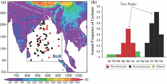
Fig. ( a) Tropical cyclone formation over the Bay of Bengal (BoB) during 1990–2009 (dots): red premonsoon; black post-monsoon; green other. (b) Annual cyclone occurrence frequency (Akter and Tsuboki 2014)
The Bay of Bengal has another important characteristic in terms of the frequency of cyclone. Cyclone is more active in the post-monsoon instead of the pre-monsoon seasons with a primary peak in November. The secondary peak is found in May (figure b). Joint Typhoon Warning Center (JTWC) records shows that in the last 20 years from 1990 to 2009, a total of 65 cyclones formed over the Bay of Bengal, 32% formed during the pre-monsoon and 62% formed during the post-monsoon season which is almost double. The remaining 6% tropical cyclones are the exception that formed in another time in the year rather than the two cyclone seasons (figure a).
It has been found that during pre-monsoon, solar heating is strong over the Bay of Bengal which increases high sea surface temperature and relative humidity. Then question arises in the mind why the number of cyclone is less in pre-monsoon than that in post-monsoon even though pre-monsoon has more favorable environment for tropical cyclone genesis.
The reader will be surprised to know that during pre-monsoon, dry and hot air from northwestern Indian region is moving into the Bay. This wind layer is vertically deep which blocks the rising of warm and moist air from the ocean surface. As the upward motion of air is prevented, no cloud can develop in the north and northwestern part of the Bay which, in turns, suppress to develop the depression. As a result no cyclone is formed in the north and northwestern part of the Bay of Bengal during pre-monsoon. On the other hand, in post-monsoon no such criterion is found for lowering the cyclone frequency. Note that research article of the same author is available in the link. http://link.springer.com/article/10.1007%2Fs00382-014-2077-9)
The writer is Associate Professor, Department of Physics, BUET, Dhaka


Comments